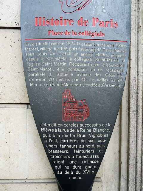
Place de la collégiale. Ici se situait jusqu'en 1874 la place centrale de Saint-Marcel, village fortifié, puis faubourg de Paris annexé sous Louis XV. C'était un ancien cloître, joignant depuis le XIe siècle la collégiale Saint-Marcel et l'église Saint-Martin. Recouverte par le boulevard Saint-Marcel, elle consistait en un rectangle parallèle à l'actuelle des Gobelins, d'environ 70 mètres par 45. La "ville" Saint-Marcel - ou Saint-Marceau - fondée au Ve siècle, s'étendit en cercles successifs de la Bièvre à la rue de la Reine-Blanche, puis à la rue Le Brun. Vignobles à l'est, carrières au sud, bouchers, tanneurs au nord, puis brasseurs, teinturiers et tapissiers à l'ouest assuraient une richesse qui ne dura guère au delà du XVIIe siècle.

English translation: "College Square. Here was until 1874 the central square of Saint-Marcel, fortified village, then suburb of Paris annexed under Louis XV. It was an ancient cloister, joining the collegiate church of Saint Marcel and the church of Saint Martin since the 11th century. Covered by Boulevard Saint-Marcel, it consisted of a rectangle parallel to the present Gobelins, about 70 meters by 45 meters. The “town” of Saint-Marcel - or Saint-Marceau - founded in the 5th century, spread in successive circles from the Bièvre to the rue de la Reine-Blanche and then to the rue Le Brun. Vineyards to the east, quarries to the south, butchers, tanners to the north, then brewers, tinters and tapissiers to the west ensured a wealth that lasted hardly beyond the seventeenth century. [AWS Translate]"

83 Boulevard Saint Marcel, Paris
Google Streetview OpenStreetMap

by City of Paris Part of the Histoire de Paris series

Colour: brown

Wikimedia:

Flickr:

Subjects

None identified yet. Subjects are curated by hand so please bear with us.