River Hull

man

Aged unknown

The River Hull is a navigable river in the East Riding of Yorkshire in Northern England. It rises from a series of springs to the west of Driffield, and enters the Humber Estuary at Kingston upon Hull. Following a period when the Archbishops of York charged tolls for its use, it became a free navigation. The upper reaches became part of the Driffield Navigation from 1770, after which they were again subject to tolls, and the section within the city of Hull came under the jurisdiction of the Port of Hull, with the same result. Most of its course is through low-lying land that is at or just above sea level, and regular flooding has been a long-standing problem along the waterway. Drainage schemes to alleviate it were constructed on both sides of the river. The Holderness Drainage scheme to the east was completed in 1772, with a second phase in 1805, and the Beverley and Barmston Drain to the west was completed in 1810. Since 1980, the mouth of the river has been protected by a tidal barrier at the estuary, which can be closed to prevent tidal surges entering the river system and causing flooding upriver. Most of the bridges which cross the river are movable, to allow shipping to pass. There are six swing bridges; four bascule bridges, two of which have twin leaves, one for each carriageway of the roads which they carry; and three Scherzer lift bridges, which are a type of rolling bascule bridge. The former Scott Street Bridge (taken out of use 1994 and dismantled 2020) was originally powered from a high pressure water main maintained by the first public power distribution company in the world.

DbPedia
Wikidata Wikipedia

Commemorated on 1 plaque

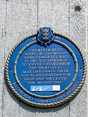
The River Hull rises on the Wolds near Elmswell and flows southwards to enter the Humber. The name Hull may orginate from old Scandinavian for 'Deep One' or celtic for 'Muddy One'.

Tidal Barrage, Hull, United Kingdom where it was