United States / Mount Vernon, KY

all or unphotographed
1 plaque 0% have been curated
no subject

Area is not geolocated yet

Open Plaques is quite smart. When a few plaques have been geolocated it will use the average to define where this area is.

If you would like to see the map a bit sooner then you could help us.

Just find 'Mount Vernon, KY, United States' on Google Maps and tell us the .

We will extract the geolocation. Probably.

courthouselover on Flickr All Rights Reserved
Kentucky Historical Marker #1254

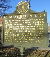
Rockcastle County, 1810. The 52nd Kentucky county created, out of Knox, Lincoln, Madison, Pulaski counties. Isaac Lindsey, who came here with a hunting party in 1767, observed a lone rock which resembled an ancient castle. From this the river was named, later the county. Dr. Thomas Walker and party, first white men to visit the interior of Kentucky, were at this rock as early as 1750.

Courthouse lawn, US 25, Mount Vernon, KY, United States