
Nevada Historical Marker #264
Silver City School House. The growing town of Silver City built a schoolhouse at this site in 1867-1868. Enrollment was as high as 166 students during the 1880s. Children were educated here for nearly a century until the school closed in 1958.The building then began its career as the Silver City community center and volunteer fire department. The fire department parked trucks inside the south classroom. Community events took place in the north classroom.Fire destroyed the schoolhouse in 2004. The community center was built in 2007 on the same place. The new building closely resembles the old schoolhouse in size and architectural style. Materials from the original building are incorporated into the new structure.
, Silver City, NV, United States

Nevada Historical Marker #265
Governor Emmet Derby Boyle. Eight grave sites to the north rests Emmet Derby Boyle (1879-1926), the first native-born governor of Nevada, serving from 1915-1923. Born in Goldhill, Boyle was also the first graduate of the University of Nevada to become governor. At thirty-five, he was the youngest person to hold the state’s highest office.Governor Emmet Boyle worked on Nevada’s water laws and introduced the state’s first executive budget. A strong supporter of women’s rights, Boyle called the Nevada Legislature into special session in 1920 to ratify the 19th amendment to the United States Constitution granting women the right to vote.Emmet Boyle died on January 3, 1926 and is buried next to his wife Vida McClure Boyle who he married in 1903.
Mountain View Cemetery, Reno, NV, United States

Nevada Historical Marker #266
African Americans And The Boston Saloon. Between 1866 and 1875, a remarkable business thrived directly behind this building. Free-born William A.G. Brown operated his Boston Saloon, serving Virginia City’s African Americans. Archaeologists have revealed that Brown offered his customers finely prepared meals with the best cuts of meat. Shortly after Brown sold his business, the great fire of 1875 swept through town and destroyed the building. There were rarely more than one hundred African Americans living in Virginia City, but they played varied and important roles in the community. Some African Americans pursued work as laborers, porters, and barbers. Others became affluent business owners, and a prominent doctor won widespread respect. By the 1870’s, African American children attended integrated schools. Prejudicial laws and racism placed hurtful restrictions on the African Americans of Nevada. Fortunately, a prevalent pro-Union, anti-slavery attitude improved the lives of many African Americans who helped build Virginia City.
Union St, Virginia City, NV, United States

Nevada Historical Marker #267
Galena Creek Fish Hatchery. The Galena Fish Hatchery represents an attempt to make amends after Nevada’s Comstock Lode ravaged the region’s ecosystem in the 1860s and 1870s. Fishing decimated local streams and lakes to feed a growing population. Eventually, restocking became an important goal.Washoe County operated this hatchery from 1931 to 1949 as an auxiliary to their main facility on the Truckee River in Reno. Galena Creek was ideal because of the continuous supply of uncontaminated water. The hatchery reflects a trend, beginning in the 1920s, to combine habitat conservation and recreational developmentThe county ceased hatchery operations in 1949. After that, the Boy Scouts, the Sierra Sage Council of Camp Fire, Inc., and the Washoe Bowmen and Sierra Archers used the site. In 1994, Washoe County reacquired the property as part of Galena Creek Regional Park with plans to restore the building for community use.NEVADA
Galena Creek, Reno, NV, United States

Nevada Historical Marker #27
Grimes Point. Grimes Point, one of the largest and most accessible petroglyph sites in Northern Nevada, contains about 150 basalt boulders covered with more than 1,000 petroglyphs. Nevada petroglyphs were of magico-religious significance, insuring the success of large game hunts and were located near seasonal migration routes.Running east and west along the ridge, on the hill above the petroglyphs, there is evidence of an aboriginal drift fence for driving deer or antelope. This required concentrated group action in construction and operation.The act of making a petroglyph was a ritual performed by a group leader before each hunt. Evidence suggests that there existed a powerful taboo against tampering in places, for purposes, and by persons other than those directly associated with the hunt.Petroglyphs probably date between 2500 and 500 years ago.
, Fallon, NV, United States

Nevada Historical Marker #270
The Morelli House. The Morelli House is a classic example of Las Vegas mid-century residential architecture. It was built in 1959 by the Sands Hotel orchestra leader Antonio Morelli and his wife Helen. Originally located at 52 Country Club Lane in the former Desert Inn Country Club Estates, now the Wynn resort, the modernistic house then featured an open plan that integrated interior and exterior spaces, natural materials, and the latest innovative home appliances. In 2001, the Junior League of Las Vegas relocated the Morelli House to its present site and completed restoration in 2009.Listed 2001, Nevada State Register of Historic PlacesListed 2007, City of Las Vegas Historic Property RegisterThis historic preservation project was funded, in part, by the Nevada Commission for Cultural Affairs and through generous donations from the Las Vegas community and members of the Junior League.
E Bridger Ave, Las Vegas, NV, United States
Nevada Historical Marker #271
Pony Express Route 1860 Sesquicentennial 2010. One hundred and fifty years ago, the Pony Express was founded by W.H. Russell, Alexander Majors and William B. Waddell, operators of the Overland Stage Line of Leavenworth, Kansas. During a visit to Washington, Mr. Russell was urged by California Senator William Gwin to expand the Overland Stage operation to facilitate faster mail service. Mr. Russell’s partners hesitated due to projected high costs; he persevered and the first ride began on April 3, 1860.Overland stagecoach stations were located every 10-12 miles as far as Salt Lake City. Eighty skilled and experienced riders, 400 horses and approximately one hundred-eighty-four stations were built in two months. There were thirty stations across Nevada, from Deep Creek, Utah to Genoa at the eastern base of the Sierra. The swift riders carried the mail 2000 miles in 10 days from St. Joseph, Missouri to Sacramento, California. The “Pony” improved nationwide communication, western expansion and was credited with California’s continued participation in the Union at the beginning of the Civil War.A high price was paid for the improved communication including the cost to post a letter and the trials of the employees during the ride. The cost of mailing a letter as advertised was not economical, “letters less than ¼ oz cost $5.00 and so on.” The riders, station masters and division agents faced hostile environments including poor housing, extreme heat and cold, poor access to potable water, food and dangers due to the conflicts between Native Americans and the newcomers to the West.On October 24, 1861, the telegraph was born and the last ride was completed. What had taken ten days could be achieved in ten seconds thus ending the Pony Express, but the memory of the riders and the route live on.STATE OF NEVADA HISTORICAL
, Fallon, NV, United States
Nevada Historical Marker #28
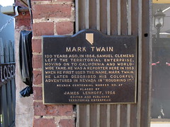
Mark Twain. 100 years ago, in 1864, Samuel Clemens left the territorial enterprise, moving on to California and worldwide fame. He was a reporter here in 1863 when he first used the name, Mark Twain. He later described his colorful adventures in Nevada in “Roughing It.”
C Street, Virginia City, NV, United States
Subjects


Nevada Historical Marker #29
Chinese In Nevada. 1864-1964 This honors the heroism and hardihood of the thousands of Chinese Americans who played a major role in the history of Nevada. From across the Pacific, the Chinese came to California during the Gold Rush of ′49 and on to the mountains and deserts of this state where they built railroads, cut timber, and performed countless tasks. Sizable Chinese communities grew up in Virginia City and other towns. Their contribution to the progress of the state in its first century will be forever remembered by all Nevadans.
Victorian Ave, Sparks, NV, United States
Nevada Historical Marker #3
West End Of Hastings Cutoff. Across the Humboldt Valley southward from this point a deeply incised canyon opens into a valley. Through that canyon along the South Fork of the Humboldt River ran the disaster-laden route called the Hastings Cutoff. It joined the regular Fort Hall route running on both sides of the Humboldt here. The canyon was first traversed in 1841 by the Bartleson-Bidwell Party, the earliest organized California emigrant group. In 1846, Lansford Hastings guided a party through this defile of the South Fork and out along the Humboldt. The ill-fated Reed Donner Party followed later the same year.By 1850, the dangers of the cutoff route were recognized and it was abandoned.
Dwight D Eisenhower Highway, Elko, NV, United States

Nevada Historical Marker #30
Reno. Before the arrival of the European Americans, the Washoe and Paiute people inhabited the Truckee Meadows. The Stevens-Murphy emigrant party passed through the area in 1844, and settlement began in the early 1850s. Charles William Fuller established a river ferry across the Truckee in the fall of 1859 and completed a bridge and a hotel by the spring of 1860. Myron C. Lake acquired Fuller’s holdings in 1861, rebuilt the bridge, and established Lake’s Crossing. In 1868, Lake offered land for a depot to the Central Pacific Railroad and the town was laid out. The community’s name honors a Civil War officer, General Jesse Lee Reno.Reno’s transcontinental railroad connection and its rail link to the Comstock Lode helped lay the foundation for the economy, as did the lumber industry and the surrounding ranches and farms.The community’s reputation as a divorce center began in 1906 and gambling was legalized in 1931.
South Virginia Street, Reno, NV, United States

Nevada Historical Marker #31
Old Spanish Trail. Stretching for 130 miles across Clark County, this historic horse trail became Nevada’s first route of commerce in 1829 when trade was initiated between Santa Fe and Los Angeles. The trail was later used by the wagons of the “49ers” and by Mormon pioneers. Concrete posts marking the trail were erected in 1965.
West Mesquite Blvd, Mesquite, NV, United States
Nevada Historical Marker #32
Old Spanish Trail. Stretching for 130 miles across Clark County, this historic horse trail became Nevada’s first route of commerce in 1829 when trade was initiated between Santa Fe and Los Angeles. The trail was later used by the wagons of the “49ers” and by Mormon pioneers. Concrete posts marking the trail were erected in 1965.NEVADA
E Washington Avenue, Las Vegas, NV, United States

Nevada Historical Marker #33
The Old Spanish Trail 1829 1850. Stretching for 130 miles across Clark County, this historic horse trail became Nevada’s first route of commerce in 1829 when trade was initiated between Santa Fe and Los Angeles. The trail was later used by the wagons of the “49ers” and by Mormon pioneers. Concrete posts marking the trail were erected in 1965.
Village Blvd, Blue Diamond, NV, United States

Nevada Historical Marker #34
The Old Spanish Trail 1829 1850. Stretching for 130 miles across Clark County, this historic horse trail became Nevada’s first route of commerce in 1829 when trade was initiated between Santa Fe and Los Angeles. The trail was later used by the wagons of the “49ers” and by Mormon pioneers. Concrete posts marking the trail were erected in 1965.
, Mountain Springs, NV, United States
Nevada Historical Marker #35
Las Vegas Old Mormon Fort (Nevada’s Oldest Building). Las Vegas had its beginning at this location on June 14, 1855, when thirty-two Mormon missionaries arrived from Utah under the leadership of William Bringhurst. They set to work establishing farm fields that summer, and began to build a 150-foot square adobe fort that September, enclosing eight two-story houses. They cultivated small gardens and fields, planted fruit and shade trees, and tried to convert the local Southern Paiutes.Most of the Mormons departed in 1857, and by 1865, Octavius Decatur Gass began developing the Las Vegas Rancho, using the adobe structures as headquarters. He farmed and raised beef cattle, supplying travellers and miners in the Potosi region.Helen J. Stewart, owner of the property from 1882 to 1902, expanded the ranch to 1,800 acres, which she sold to the San Pedro, Los Angeles & Salt Lake Railroad for the Las Vegas townsite. The Company auctioned the land on May 15, 1905, starting the process of building the Las Vegas around you today.
E Washington Avenue, Las Vegas, NV, United States

Nevada Historical Marker #36
Moapa Valley. Rich in Pueblo-type culture, and noted by the explorer Jedediah Smith in 1826, Moapa Valley is crossed by the Old Spanish Trail.In 1865, Brigham Young sent 75 families to settle the area, to grow cotton for the people of Utah, and to connect Utah with the Pacific Ocean via the Colorado River.Located near the junction of the Muddy and Virgin Rivers, and now under Lake Mead, the “cotton mission” was named St. Thomas for its leader, Thomas Smith. Mormons built a prosperous, self-contained agricultural industry in the valley, which included orchards, vineyards, cotton, grains, and vegetables.The December 1870 survey placed the valley in Nevada, which meant property owners owed back taxes to Nevada. The settlers, now including those in St. Joseph, (old) Overton, West Point, and Logandale, began leaving two months later. They abandoned the results of 7 years of labor, more than 18 miles of irrigation canal, and several hundred acres of cleared land.Other Mormons resettled the land in 1880. The area remains one of the most agriculturally productive in the state.
N Moapa Valley Blvd, Moapa Valley, NV, United States

Nevada Historical Marker #37
Powell Of The Colorado. On August 30, 1869, Major John Wesley Powell landed at the mouth of the Virgin River, about twelve miles south of here, thus ending the first expedition through the Grand Canyon of the Colorado River.The expedition left Green River City, Wyoming Territory, on May 24, 1869. For three months Powell and his men endured danger and hunger to explore, survey, and study the geology of the canyons along the Green and Colorado Rivers.Exhausted and near starvation, the Powell party was fed by the Mormons of St. Thomas, a small farm settlement about eleven miles north of here.The original sites of St. Thomas and the junction of the Virgin and Colorado Rivers are now beneath the waters of Lake Mead.This, and later Powell surveys, stimulated interest in the water conservation problems of the Southwest.
Echo Bay Road, Overton, NV, United States

Nevada Historical Marker #38
Pahranagat Valley. Pahranagat Valley is named after a local Shoshone Native American Tribe. Three local springs fill the valley’s lakes, which farmers have used for irrigation since the mid-nineteenth century.In the late 1860s, outlaws pastured hundreds of head of stolen cattle in the valley meadows. In 1865, ore was discovered in the area. The following year, a stamp mill was established at Hiko, twenty miles to the north to crush the ore. Hiko became the center of activity for the valley and the county seat between 1866 and 1871, when local mining declined and Pioche claimed the county seat.The valley received international notoriety in 1867 when Dan De Quille of the Territorial Enterprise published an article titled “The Rolling Stones of Pahranagat,” about magnetic traveling stones. De Quille was notorious for publishing comedy and satire, sometimes mistaken by his readership for truth. In this case, De Quille described these round stones as having a magical quality that, when scattered on the floor, would immediately began travelling toward a common center. De Quille published similar articles on the stones in 1876, 1879, and 1892.The town of Alamo before you, established in 1900, is the valley’s largest present-day settlement. Watered by Pahranagat Creek, the area includes several ranches and the Pahranagat Valley National Wildlife Refuge.
Great Basin Highway, Alamo, NV, United States

Nevada Historical Marker #39
Panaca. Southern Nevada’s first permanent settlement was established as a Mormon colony by Francis C. Lee and others in 1864. Poor in resources, but rich in people, Panaca has changed little through the years. Although mining at nearby Bullionville and Pioche has had its effect, Panaca remains an agricultural community.The post office was established in 1867, moved to Bullionville in 1874, and returned in 1879. During the 1870s, coke ovens produced charcoal here for the smelters at Bullionville.Originally located in Washington County, Utah, Panaca became part of Nevada by an act of Congress, dated May 5, 1866. As the boundary was not then surveyed, a dispute arose over taxes levied by Lincoln County, Nevada. The matter settled in favor of the Panaca citizenry on December 4, 1871, after a long period of bitter litigation.
Main St, Panaca, NV, United States