
Nevada Historical Marker #76
Eagle Valley. Centrally located between one of the first Nevada settlements at Genoa and the gold and silver of the Comstock Lode, Eagle Valley, site of present Carson City, was a vital link inland communications.One of the key California emigrant routes, the Carson branch of the California Emigrant Trail crossed the Sierra Nevada at Kit Carson Pass and came through Eagle Valley roughly along Sage Drive, a block east of this point.The first overland telegraph, colloquially known as Fred Bees “Grapevine” was completed from Placerville to Carson City in 1859. In this area, the line followed what is now highway U.S. 395. The Pony Express (1860-1861) and the Butterfield-Wells Fargo Overland Stages (1862-1868) followed the same route.The Virginia & Truckee Railway in its extension to Carson Valley and Minden in 1906 used the route about six blocks east of Bigelow Drive.
, Carson City, NV, United States

Nevada Historical Marker #77
Dat So La Lee. Famed Washoe basket maker, Datsolalee, is buried in this cemetery along with many other Washoe weavers. Also known as Louisa Keyser. Dat So La Lee, and Dabuda, over 120 of her major documented baskets were made expressly for sale to Arts and Crafts collectors from 1895 until her death in 1925 under patronage of the Cohn family. Datsolalee’s baskets are prized by collectors and displayed in museums across the country.Utilitarian, straight-walled, decorated coiled willow basketry is a Washoe tradition extending back thousands of years. Datsolalee brought international fame to the spherical Washoe degikup willow basket and highlighted the form with innovative decorative motifs in bracken fern and redbud Fibers. She and her patrons promoted this craft to the public, elevated it to an art form, and, most importantly, motivated basketry production by other tribal members during a period when the Washoe were recovering from mid-nineteenth- century loss of their homelands and aboriginal life ways.
, Carson City, NV, United States
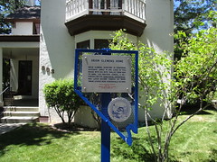
Nevada Historical Marker #78
Orion Clemens Home. Orion Clemens, secretary to territorial Governor James W. Nye, lived in this house with his wife, “Mollie,” from 1864 to 1866. Samuel, his brother who was a reporter for the Territorial Enterprise, stayed here periodically until leaving the territory in May 1864. He became famous as “Mark Twain.”
, Carson City, NV, United States
Subjects


Nevada Historical Marker #79
Grand Army Of The Republic Cemetery. In 1890 General OM. Mitchel Post 69, Grand Army of the Republic, bought 17 lots in the original Hillside Cemetery for the last resting place for comrades-in arms during the Civil War, 1861-1865.While Friends and relatives of the soldiers maintained the cemetery well, years of neglect and vandalism followed in the twentieth century. Restoration began in 1963 by the Daughters of Union Veterans of the Civil War and other interested citizens of the Reno area.Among those buried here are members of the Nevada volunteers who served in their own state and neighboring areas of the West from 1861 -1866.
West 10th St, Reno, NV, United States

Nevada Historical Marker #8
Austin. Austin sprang into being after William Talcott discovered silver at this spot on May 2, 1862. Talcott came from Jacobsville, a stage stop six miles to the west on the Reese River. He was hauling wood out of Pony Canyon, directly below, when he made the strike that set off the famous “Rush to Reese.” A town called Clifton flourished briefly in Pony Canyon but fast growing Austin soon took over and became the Lander County seat in 1863. Before the mines began to fail in the 1880s Austin was a substantial city of several thousand people. From Austin, prospectors fanned out to open many other important mining camps in the Great Basin.
Lincoln Highway, Austin, NV, United States

Nevada Historical Marker #80
Eureka Courthouse. The Eureka County Courthouse, designed by George Costerisa, cost about $38,000 to construct. Built in 1879-80 of locally-fired brick and of sandstone quarried nearby, the Italianate style courthouse remains a fine example of boomtown Victorian opulence. This relic, a scene of many famous trials, reflects the glory days from 1864 to 1890 when Eureka was the first important lead-silver district in the United States.
Lincoln Highway, Eureka, NV, United States

Nevada Historical Marker #81
Grand Army Of The Republic Tree. This tree was planted in soil from Civil War battlefields and dedicated to the memory of the Grand Army of the Republic by the national commander in chief June on 10, 1913. It was dedicated by Isaac Crist Camp No. 28, Sons of Union Veterans of the Civil War, and Johana Shine Tent No. 82, Daughters of Union Veterans of the Civil War in Reno, Nevada, October 18, 1969.
East 9th St, Reno, NV, United States
Nevada Historical Marker #82
Diamond Valley. The first known explorer of Diamond Valley was Captain John C. Frémont who mapped the area to aid western migration in 1845. Before Frémont, Shoshone and Paiute Indians had gathered nature’s bounty here.Colonel J.H. Simpson mapped a route through the valley in 1859. The Simpson route, through the north end of the valley, immediately became the Pony Express route from 1860-1861. The Overland Telegraph replaced the Pony Express and also crossed the valley.Early freight toll roads were operated across the valley as lead and silver mining camps boomed in the 1860s. Needs of the mining camps gave rise to a limited livestock and dairy industry. In 1957, a large underground lake was tapped to supply water for irrigation.
Eureka/Carlin Rd, Eureka, NV, United States
Nevada Historical Marker #83
Rock Creek (Cold Springs Station). Rock Creek was an important stagecoach stop on the Overland Mail & Stage Company’s historic line along the Simpson route between Salt Lake City and Genoa, Nevada, which was operated by John Butterfield (1861-1 866) and later Wells, Fargo & Company (1866-1869). Fresh horses, blacksmith services, and wagon-repair facilities were available here.The Pony Express constructed the Cold Springs station in 1860 on the sagebrush bench eastward across the highway. To the north are the ruins of a telegraph repeater and maintenance station which serviced this segment of the transcontinental line, which was completed between Sacramento and Omaha in 1861. The line was abandoned in August 1869. The coming of the transcontinental railroad and its parallel telegraph line along the Humboldt River to the north spelled the demise of both the telegraph line and the stage route here.
, Fallon, NV, United States
Nevada Historical Marker #84
Jedediah Strong Smith. From May to June 1827, explorer and trapper Jedediah Smith found a route from California’s central valley to the Great Salt Lake Valley in Utah. He became the first European American to completely cross what is now Nevada.Because Smith’s journal and map have never been found, his exact route is unknown. Based on Smith’s own statements about his difficult trip, modern historians and geographers have pieced together the most plausible route. Smith crossed the Sierra Nevada at Ebbetts Pass, swung southeast along or across the headwaters and middle reaches of the Walker River, and passed into central Nevada’s open spaces south of Walker Lake.Smith entered Smoky Valley on its southwest side in June 1827 and crossed the valley in a northeasterly direction. He then paralleled the future Simpson survey, route of the Pony Express and Overland Stage, along modern U.S. Highway 50.He entered Utah at Ibapah.
Great Basin Highway, Ely, NV, United States
Nevada Historical Marker #85
Sutro. Sutro was a town, a tunnel, and a man. The well-planned community was headquarters for the Sutro Drainage Tunnel.German-born Adolph Sutro came to the Comstock in 1860. He advocated a drainage tunnel, visualizing development of Comstock ore with this access. By 1865, his vision gained approval of state and federal legislation. However, the mining interests, having at first supported the tunnel, became strongly opposed.When construction began in 1869, it was first financed by the mine workers since the tunnel would presumably improve mine safety. Later, the funding came from international bankers. Miners completed the main tunnel in 1878 and then extended lateral excavations, providing drainage, ventilation and access to many Comstock mines. The work on the tunnel from its lower end created a town of 600-800 and boasted of a church, post office and its own weekly newspaper, plus Sutro’s Victorian mansion and other fine residences. Adolph Sutro soon sold his interest in the tunnel company and returned to San Francisco, where he served as mayor.
California Emigrant Trail, Dayton, NV, United States

Nevada Historical Marker #86
Tule Springs. Tule springs is one of the few sites in the United States where evidence suggests the presence of man before 11,000 B.C.Scientific evidence shows this area, once covered with sagebrush and bordered with yellow-pine forests, had many springs. These springs were centers of activity for both big game animals and human predators. Evidence shown at these fossil springs shows the presence, 14,000 to 111000 years ago, of several extinct animals: the ground sloth, mammoth, prehistoric horse, and American camel. The first Nevada record of the extinct giant condor comes from Tule Springs.Early man, perhaps living in the valley as early as 13,000 years ago, and definitely present 11,000 years ago, was a hunter of the big game.Small populations of desert culture people, from about 7,000 years ago to the historic period, depended upon vegetable foods and small game for subsistence.Late Pleistocene geological stratigraphy in few other areas is as complete and well known.
Floyd Lamb Park, Las Vegas, NV, United States

Nevada Historical Marker #87
Savage Mansion (C. 1861). This elegant mansion, designed in the French Second Empire style, served as a residence for the superintendent, as well as a mine office for the Savage Mining Company. The first floor served as the mine office while the upper two stories provided a residence for many successful superintendents. Ulysses S. Grant, 18th President of the United States and “General of the Armies,” spoke to the townspeople from the second floor balcony on October 27, 1879, after a town parade in his honor.
D Street, Virginia City, NV, United States

Nevada Historical Marker #88
Sparks. Engaged in straightening and realigning the old Central Pacific trackage across Nevada, the Southern Pacific Company moved its shops and headquarters from Wadsworth to this location in 1904. The railroad set aside five city blocks for its employees’ residences. Each railroader paid $1.00 for a lot. They had to build a house within 120 days and file their deed of ownership. The company also cut their houses in Wadsworth into sections, loaded the parts on train cars and shipped the houses free of charge to Sparks. The railroad moved its employees, their houses, animals and personal items on July 4, 1904.Sparks, originally known as East Reno, New Town Tract and Harriman, came into official existence. In 1905, the state legislature incorporated the town, named it in honor of John Sparks, rancher and governor of the state of Nevada.Sparks boasted one of the largest roundhouses in the world during the steam era, the Nevada base for a vast stable of steam locomotives. The famous cab-in-front locomotive type known as Mallets, were the huge steamers hauling both freight and passengers over the steep grades of the Sierra Nevada between Roseville, California and Sparks.
Prater Way, Sparks, NV, United States

Nevada Historical Marker #89
Paradise Valley. Hudson Bay Company’s Peter Skene Ogden traversed Paradise Valley in November 1828. Settlers came to Paradise Valley in 1863. Conflicts with local Native Americans started the next year, causing the establishment of Camp Winfield Scott (1866-70) four miles from here. Paradise Valley farms supplied the nearby Nevada and Idaho territory mines.In the original town of Scottsdale (1866), John C. Kemler built the first hotel, now used as a residence. Renamed Paradise City (1869), the town was a mining supply center from 1878 until 1920. Later when livestock raising predominated, the town was again renamed, this time “Paradise Valley.”
North Main St, Paradise Valley, NV, United States
Nevada Historical Marker #9
Copper Country. The famed open-pit copper mines of eastern Nevada, including the Liberty Pit, largest in the state, are located two miles south of this point. Through the first half of the twentieth century, this area produced nearly a billion dollars in copper, gold, and silver. The huge mounds visible from here are waste rock, which was removed to uncover the ore.Two miles east of here, near Lane City, was the Elijah, the first mine discovered in the Robinson Mining District. Lane City, originally called Mineral City, was settled in 1869 and had a population of 400. At Mineral City was the Ragsdale Station, one hotel, and a stage station.
Lincoln Highway, Ruth, NV, United States
Nevada Historical Marker #90
Delamar, “The Widow Maker” 1893 1909. John and Olivia Ferguson discovered gold twelve miles south of here around 1891. The original name of the camp they established was Ferguson. However, it was eventually renamed "Delamar” after John DeLamar, an entrepreneur who bought the best mining claims in 1893 for $150,000. Eventually, over 1500 residents settled in this isolated place. The town contained a newspaper, hospital, school, churches, saloons, stores, a theater and professionals. Entertainment included brass bands, dance orchestras, and stage attractions at the opera house.Water came from Meadows Valley Wash 12 miles away. All other materials were hauled through the mountains by mule team 150 miles from a railroad head at Millard, Utah. For 16 years, most of the bullion was hauled out in the same manner.The dry milling processes used prior to the introduction of wet methods created a fine silica dust, or “death” dust, causing the deaths of many residents and gave the town its nickname, “The Widow Maker".Delamar produced $25,000,000 in gold and was Nevada’s leading producer at the turn of the twentieth century.
, Caliente, NV, United States

Nevada Historical Marker #91
Stewart Indian School. Originally known as the Carson Indian Training School, Stewart Indian School was operated by the U.S. Bureau of Indian Affairs to provide vocational training and academic education for American Indian students from throughout the West for nearly a century.W.D.C. Gibson, the first superintendent, renamed the boarding school in honor of U.S. Senator William Morris Stewart of Nevada. Stewart was the principal figure in obtaining congressional authorization and funding for the institution.In the early 1920s Superintendent Frederick Snyder initiated a building program at the school.Students worked with stone masons, some from the Hopi Tribe, to construct the distinctive stone structures that still grace this campus, which is listed in the National Register of Historic Places.
Snyder Ave, Stewart, NV, United States

Nevada Historical Marker #92
Candelaria And Metallic City. The ghost towns of Candelaria and Metallic City are seven miles west of here.Candelaria was reported to be named after a mine of the same name, located in the mid-1860s, and is derived from the Catholic Church’s Candelmas Day. Metallic City lies ¾ mile to the south of Candelaria.In 1880, Candelaria was the largest town in the immediate area and boasted three doctors, three lawyers, two hotels, six stores, and ten saloons. Water piped from Pinchower Creek and Trail Canyon in the mid to late-1880s caused the price of water to drop from $1.00 to $0.05 per gallon.The leading mine, the Northern Belle, was first located in 1864, but was not developed until 1870. It is reported to have produced an estimated $7 million, mainly in silver.
Candelaria Road, Coaldale, NV, United States

Nevada Historical Marker #93
Panaca Mercantile. This building, popularly known as the Panaca Co-op, was constructed of adobe in 1868. The “Panaca Cooperative Mercantile Institution” comprised more than one hundred stock holders—to meet barter, merchandising, and marketing needs. Wagons from Salt Lake drawn by 6-mule teams carried stock to Panaca, returning with produce from the region.
Lincoln County High School, Panaca, NV, United States