Places, subjects, or plaques matching "spanish civil war"
29 plaque matching "spanish civil war"
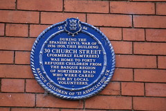
During the Spanish Civil War this building 30 Church Street (formerly Elmtrees) was home to forty refugee children from the Basque region of northern Spain who were cared for by local volunteers
30 Church Street, Sutton, Hull, United Kingdom
Subjects

From January 1938 to November 1939 twenty-nine Basque Children, refugees from the Spanish Civil War, were cared for by local volunteers in this house provided by Jesus College
1 Station Road, Cambridge, United Kingdom
Subjects
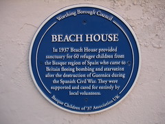
Beach House In 1937 Beach House provided sanctuary for 60 refugee children from the Basque region of Spain who came to Britain fleeing bombing and starvation after the destruction of Guernica during the Spanish Civil War. They were supported and cared for entirely by local volunteers.
Beach House, Brighton Road, Worthing, United Kingdom
Subjects

CROESO Pendragon House 18 Cross Street. From November 1939 this building was home to 30 Basque refugee children from the Spanish Civil War who were cared for by local organisations and volunteers. From 1937 to 1939 they stayed at Cambria House, Mill Street EUZKADI
18 Cross Street, Caerleon, United Kingdom
Subjects

In this house designed by architect Edgar Wood in 1898, twenty Basque children found sanctuary from the Spanish Civil War (1936-1939), cared for by local organisations and volunteers.
Almondbury, Huddersfield, United Kingdom
Subjects

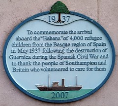
To commemorate the arrival aboard the 'Habana' of 4000 refugee children from the Basque region of Spain in May 1937 following destruction of Guernica during the Spanish Civil War and to thank the people of Southampton and Britain who volunteered to care for them
Civic Centre Road, Southampton, United Kingdom
Subjects
James Keogh 1915-1938 In honour of James Keogh of Wellington Street, Ashton-under-Lyne, who died in March 1938 at Calaceite in the Province of Aragón in Spain, fighting for freedom and democracy in the Spanish Civil War of 1936-39 and those other volunteers from this borough who also fought in Spain.
Inside Central Library, Old Street, Ashton-under-Lyne, United Kingdom
Subjects
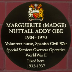
Marguerite (Madge) Nuttall Addy OBE 1904-1970 Volunteer nurse, Spanish Civil War Special Services Overseas Operative World War II Lived here 1932-1937
34 Manchester Road, Chorlton, Manchester, United Kingdom
Subjects

MARY ELIZABETH SLATER 24th January 1903 to 30th November 1983 At the start of the Spanish Civil War in 1936, Mary joined the International Brigade to help combat Franco's fascism, serving as a nurse in field hospitals. After repatriation she served as a nurse in the London blitz and then returned to nursing in Preston.
Friargate, Preston PR1 2ER, Preston, United Kingdom

Sam Wild, Commander of the British Battalion of the International Brigade in the Spanish Civil War lived here 1940 - 1959.
57 Birch Hall Lane, Rusholme, Manchester, United Kingdom
Subjects

SPANISH CIVIL WAR 1936-1939 IN HONOUR OF THE SOUTH YORKSHIRE MEN WHO FOUGHT ALONGSIDE THE SPANISH PEOPLE IN SUPPORT OF DEMOCRACY AND OF THE LOCAL MEN AND WOMEN WHO WORKED IN SUPPORT OF THE CAUSE. THESE DIED IN SPAIN M.AARONBERG (JARAMA 2.37) G.ALLSTOP (EBRO 8.38) W.BRENT (EBRO 8.38) A NEWSUM (CORDOVA 1.37) H TAGG (JARAMA 2.37) F.TURNHILL (TERUEL 1.38) THESE ALSO FOUGHT IN SPAIN J ALBAYA . A COOPER. T DEGNAN. T JAMES. J MAIDEN. R RYDER. C SMITH. A STIRLING. S WARD. H WINDLE Yet, freedom, yet thy banner torn but flying Streams like a thunderstorm aginst the wind BYRON
Peace Gardens, Sheffield, United Kingdom
Westfield House (formerly St Joseph’s) from 1937 to 1939 during the Spanish Civil War this building was home to 30 refugee children from the Basque region of northern Spain who were cared for by local volunteers
Bampton Road, Aston, United Kingdom
Subjects
Texas Historical Marker #00400
Bexar County under Nine Governments. The administrative government of Bexar County, besides being the oldest in Texas, is distinguished by having served under nine governments. The community served under Spanish rule from May, 1718, until January, 1811, when it was taken over by the revolutionary "Casas regime". Only five weeks later, the "counter-revoluationary Junta of Bexar" overthrew the Casas government and eventually restored Spanish rule. In April, 1812, however, the "Republican Army of the North" deposed the provincial Spanish government and declared independence from Spain. Five months later the Spanish regained control, holding Texas until 1821. The fifth regime, "First Imperial Government of Mexico" was created when Mexico gained independence from Spain in 1821. The emperor relinquished control to army leaders within two years, however, and the "Republic of Mexico" was established. Texas gained independence from Mexico in 1836, thereby establishing Bexar's seventh government, the "Republic of Texas". In 1845, Texas became the twenty-eighth state of the United States and remained in the Union until 1861, when the southern states seceeded to from the Confederacy. Following the Civil War, U.S. rule returned to Bexar County in 1865. (1967) #400
?, San Antonio, TX, United States
Texas Historical Marker #01441
El Sal del Rey. (The salt of the King) Directly to the north. Upon Spanish discovery, 1746, claimed for King, under old law that salt was money. People of wide area got salt here. 1863-64 works aided Texas in the Civil War. Later disputes over El Sal del Rey established Texas laws for private ownership of minerals. (1964) #1441
?, Linn, TX, United States
Texas Historical Marker #02203
Goliad County. First known to Spanish settlers as Nuestra Senora de Loreto, later called La Bahia del Espiritu Santo. Established as a mission in 1749. Became a strategic fort under Spanish, Mexican, Texas occupancy, 1810 - 1821, 1835 - 1836. Name changed to Goliad and created a Mexican municipality in 1829. Scene of massacre of Fannin and his command in 1836. Organized as a county, 1836, with town of Goliad as the county seat. Home of Confederate General Hamilton P. Bee. From population of 3,384 county sent several army companies to the Civil War. #2203
?, Goliad, TX, United States
Texas Historical Marker #03304
McMullen County. Created 1858. Organized 1862. Abandoned because of bandit activities in thicket area during the Civil War. Reorganized 1877, with Tilden as county seat. Named for John McMullen (1785-1853), founded with James McGloin of the Irish Colony at San Patricio; President Pro Tempore of the General Council which governed Texas in 1836, on the eve of the Republic. Of the 254 Texas counties, 42 bear Indian, French or Spanish names. 10 commemorate such colonizers as McMullen and Stephen F. Austin, "Father of Texas". 12 honor Washington and other American patriots. 96 were named for men who fought in the Texas war for independence (15 dying at the Alamo), signed the Declaration of Independence from Mexico, or served as statesmen in the Republic of Texas. 23 have the names of frontiersmen and pioneers. 11 honor American statesmen who worked for the annexation of Texas; 10, leaders in Texas since statehood, including jurists, ministers, educators, historians, statesmen; and 36, men prominent in the Confederacy during the Civil War. Rockwall and 8 others have geographical names. San Jacinto and Val Verde were named for battles; Live Oak and Orange, for trees; and Mason for a fort. 1964 #3304
?, Tilden, TX, United States
Texas Historical Marker #04032
Pioneer Rest Cemetery. Burial plot was begun by Adam Bradford, who buried his father, Jack Bradford, here in 1863. As the town and cemetery grew, the city bought the tract from Mrs. Gustav E. Schleicher in 1904. Fence surrounding cemetery was built of stone from the old courthouse and jail, razed in 1931, and reputed to have been in the original structure of nearby San Luis de Las Amarillas (Built by the Spanish in 1757). Final resting place for many area pioneers, including soldiers, cowboys, gamblers, preachers, civil war veterans, Indian fighters, and Texas Rangers. #4032
US 83, S side of Menard, Menard, TX, United States
Texas Historical Marker #05208
Taylor County. Created 1858. Named for Edward, James and George Taylor, 18, 20, and 22, Tennesseans who came to Texas in 1833 and died at the Alamo, March 6, 1836. Organized 1878, with county seat at Buffalo Gap, through which went the Fort Concho to Fort Belknap stagecoach and longhorns on western trail up to Kansas. County seat was moved to Abilene in 1883. Of the 254 Texas counties, 42 bear Indian, French or Spanish names. 10 honor such colonizers as Stephen F. Austin, "Father of Texas". 12 were named for Washington, Clay and other American patriots. 96 were named for men like the Taylors who fought in the Texas War for Independence (15 dying at the Alamo), signed the Declaration of Independence, or served as statesmen in the Republic of Texas. 23 have the names of frontiersmen and pioneers. 11 honor American statesmen who worked for the annexation of Texas; 10, leaders in Texas since statehood, including jurists, ministers, educators, historians, statesmen; and 36, men prominent in the Confederacy during the Civil War. El Paso and 8 others have geographical names, San Jacinto and Val Verde were named for battles; Live Oak and Orange, for trees; and Mason for a fort. (1964) #5208
US 83/84, S. of Abilene, Abilene, TX, United States
Texas Historical Marker #07553
Burleson County. Farmed early as 1744 by Indians under guidance of Spanish missionaries. In 1830, Ft. Tenoxtitlan, guarding Brazos crossing, San Antonio Road, attracted Anglo-Texans, who lived off wild game in early years. County created and organized in 1846. Named for Gen.Edward Burleson (1798-1851), veteran of Battle of San Jacinto; Indian fighter; Republic of Texas vice-president and senator, later a state senator. County seat, Caldwell (named for Mathew Caldwell, signer of Declaration of Independence). During the Civil War, furnished troops, cotton and food to Confederate Texas. (1965) #7553
?, Caldwell, TX, United States
Texas Historical Marker #09395
Liendo Plantation. 1853 - named for Spanish grantee Justo Leindo, first to own this land. Mansion built by Leonard W. Groce, who surrounded it with model plantation industries. In Civil War, site of Camp Groce, a camp of instruction and then P.O.W. center. Occupied in 1865 by Gen. Geo. W. Custer, later to be a central figure in the Little Big Horn tragedy. Owned, 1873-1911, by family of sculptress Elisabet Ney, commemorated with a marker on grounds. Recorded Texas Historic Landmark - 1964 #9395
5 mi. N on FM 1488 to Wycliff Chapel Rd., Hempstead, TX, United States
Texas Historical Marker #10549
Opelousas Trail. Named for one of several Atakapan-speaking Native American tribes originally connected by this trail, the Opelousas ran from La Bahia (later Goliad) to the Mississippi River in Louisiana. Evidence of cultural interchange between tribes indicates the presence of such a trail for hundreds of years. Spanish explorers, soldiers, and vaqueros employed this route. by the 1750s, French traders had been traveling the trail for about twenty years. After 1820 settlers began to arrive from Louisiana and other southern states. Don Martin de Leon and Anglo cattlemen such as James Taylor White and William B. Duncan herded large droves of cattle, mules, and horses to market in New Orleans. A post route was established along the Opelousas in early 1836. That spring, Texas pioneers fled along this path during the "Runaway Scrape." Later Santa Anna was led down the trail toward New Orleans and ultimately to Washington, D. C., as a prisoner of war. A stage and mail route followed the trail after 1850; the Confederate Army used the road to move troops during the Civil War. Use of the route continued throughout the 20th century. Many segments of the trail were incorporated into U. S. Highway 90 from Liberty to Orange. (1998) #10549
Hwy. 90, Nome, TX, United States
Texas Historical Marker #11682
Humboldt Cemetery. The community of Humboldt began to prosper when a caravan of families arrived from Tennessee in 1866. The first burial on this site probably was that of Katharine Rankin, the infant daughter of William J. and Mary Rankin, in 1868. The oldest marked grave is that of Mary Rankin's father, Adam E. Dinsmore, who died in 1876. The heirs of Adam and Mary (Davis) Dinsmore deeded this land as a burial ground in 1890. The presence of 38 marked infants' graves before 1932 is indicative of the hardships of pioneer life. One of the graves is that of Maggie C. Dinsmore, a teacher who died during the 1918 Spanish flu epidemic. Six graves are those of Civil War veterans. At the dawn of the 21st century, Humboldt Cemetery covers about four acres. (2000) #11682
5 mi. NE on SH 224, then 4 mi. E on FM 2736, Greenville, TX, United States
Texas Historical Marker #12064
Military Highway of the Lower Rio Grande Valley. Plains Indians made trails near the banks of the rio Grande that were used by Spanish explorers in the 18th century. Early settlers built a road close to the river bank connecting their ranches. Later called the Military Road, it ran from Brownsville to Laredo, linking frontier forts and stagecoach and mail lines. An inland route for cotton shipping during the Civil War, parts of it also were used for cattle drives. It served as the military telegraph road between Forts Brown and McIntosh in the 1870s. Paved by the 1940s, the highway is a significant part of the region's history. (1997) #12064
?, Mercedes, TX, United States
Texas Historical Marker #12108
The University Tradition in Nacogdoches. The Spanish friars who built the Mission of Our Lady of Nacogdoches passed to the townspeople a sense of scholarship and educational responsibility. Prominent citizens such as Sam Houston and Thomas J. Rusk were well known for their attention to education. Town citizens pursued the establishment of a university in the 1840s. The Republic of Texas granted a charter for a school in February 1845. Nacogdoches University was a preparatory school with some college subjects included in the curriculum. Townspeople gave money, materials, land and labor to support the school and secure for their children the best education possible. The school moved into its permanent home on Washington Square in 1858. Hard times began with the Civil War; later, several entities operated the institution, including the Catholic church, local Masons, and Keachi College of Louisiana. In 1904, the trustees deeded the campus to the newly created public school district of Nacogdoches. Citizens began a movement in 1906 to lobby for the formation of a new college. This culminated in the first, although ultimately unsuccessful, attempt to establish an east Texas normal school in 1915. When legislation in 1917 called for a college "east of the 96th meridian," Nacogdoches organized a citizens' committee. A pamphlet entitled "twenty-three reasons why Stephen F. Austin State Normal College ought to be located at Nacogdoches..." stated their case. As they had 70 years earlier, the people of Nacogdoches lobbied heavily for the new college, pledging 208 acres of land, 250 students, paved streets, and free electricity to the institution. When the opening was postponed from the summer of 1923 to the fall, the two recruited students from all of east Texas and even supplied a temporary home for a year -- Washington Square. (1999) #12108
1936 North St., Nacogdoches, TX, United States
Texas Historical Marker #12297
Old Alice Road. Once used by Indian tribes, then widened by Mexican oxcarts and Spanish expeditions, this trail has been called the Old Alice Road since its establishment as a stagecoach line from San Antonio to Brownsville in the 1860s. It was the main route between Brownsville and central and east Texas. Dubbed "The Cotton Road" in the Civil War, when Union troops blockaded Texas ports, this was the route by which cotton was moved down to Mexico. When the railroad arrived in south Texas in 1904, the old stage route fell into disuse. By the late 20th century, only impressions of the trail remained. (1997) #12297
?, La Jarita, TX, United States
Texas Historical Marker #12684
Morris County. Created and organized in 1875, with Daingerfield as county seat. Named for William W. Morris (1805-1883), who came to Texas in 1849. When the Civil War began in 1861, was in 8th Legislature that armed the state, enacted soldiers' families' relief laws and set up 2,000 mile frontier and coastline defenses. Also in 13th Legislature, 1873-75. Of the 254 Texas counties, 42 bear Indian, French or Spanish names. 10 honor such colonizers as Stephen F. Austin, "Father of Texas". 12 were named for Washington, Clay and other American patriots. 96 were named for men who fought in the Texas War for Independence (15 dying at the Alamo), signed the Declaration of Independence from Mexico, or served as statesmen in the Republic of Texas. 23 have the manes of frontiersmen and pioneers. 11 honor American statesmen who worked for the annexation of Texas; 10, leaders in Texas since statehood, including jurists, ministers, educators, historians, statesmen; and 36, men like Morris prominent in the Confederacy during the Civil War. Delta and 8 others have geographical names. San Jacinto and Val Verde were named for battles; Live Oak and Orange, for trees; and Mason for a fort. #12684
US 67 E in roadside park, Naples, TX, United States

The Washington Artillery. (141st Field Artillery) Organized May 1838 -- Service with General Zachary Taylor's Army Texas Aug. -- Nov. 1845 service with General Taylor in Texas - Mexico 1846 -- Service Confederacy Army May 1861 to May 1865 -- Spanish-American War -- Mexican border June 1916 to Feb. 1917. WWI April 1917 to May 1919 -- WWII Jan.1941 to Dec. 1945. Emergency and disaster relief service many times. Civil War: First Manassas, Peninsula, Second Manassas, Shiloh, Sharpsburg, Fredericksburg, Chancellorsville, Gettysburg, Chickamauga, Petersburg, Wilderness, Spotsylvania, Murfreesborough, Appomattox. World War II: Algeria - French Morocco, Anzio, Ardennes-Alsace, Central Europe, Naples-Foggia, Normandy, North Appennines, Northern France, Po Valley, Rhineland, Rome-Arno, Sicily, Southern France, Tunisia. "Try Us"
Decatur Street, opposite Jackson Square, New Orleans, LA, United States
Texas Historical Marker #11627
Rice. Settlers began arriving at this site in the late 1860s, mostly from the nearby settlement of Porter's Bluff, which had been devastated by a flood in 1866. By 1872, the Houston and Texas Central Railroad, which bypassed Porter's Bluff, was routed through this site. One of the railroad's principal investors, Houston businessman William Marsh Rice (1816-1900), donated five hundred acres of land for a station and a townsite, which was named in his honor. The Rice Post Office was established in 1872. Cotton was the main crop of the area, and accounted for much of the community's business interests. One of the first businesses in Rice was a cotton gin, and the Rice Railroad Station was a major cotton shipping point. A train carrying Spanish-American War recruits came through the station in 1898, and the Liberty Bell passed through on a World War I Liberty Bond campaign. Early settlers of Rice included Isaac Sessions, who arrived in 1846; Texas Revolutionary War veteran Joseph Calloway Bartlett, who was Rice's first postmaster; and many Civil War veterans. The community's first school opened in 1875. Citizens voted to incorporate the city in a December 1912 election. Texas Sesquicentennial 1836-1986 #11627
?, Rice, TX, United States
Subjects


¿Sabías que estos muros albergaron en su interior un refugio antiaéreo durante la guerra civil española, siendo usado por los castreños para salvaguardarse de los bombardeos? Como la mayoría de los refugios, contaba con dos puertas, una en cada extremo, y unos agujeros que hacían de respiradores. Las personas debían estar muy juntas para poder entrar el mayor número. El espacio era muy reducido y contaban con unos pequeños listones de madera para que la gente mayor, enfermos y niños pudieran sentarse en tan larga espera. Para hacer uso del bunker había unas normas de convivencia, desde la prohibición de fumar, permanecer en silencio o agruparse en el centro por ser el lugar más seguro.
English translation: Did you know that these walls housed inside an air raid shelter during the Spanish civil war, being used by the Castreños to protect themselves from bombing? Like most shelters, it had two doors, one at each end, and some holes that acted as respirators. People had to be close together to be able to enter the greatest number. The space was very small and they had small wooden slats so that the elderly, sick people and children could sit in such a long wait. To make use of the bunker there were some rules of coexistence, from the prohibition of smoking, staying silent or grouping in the center because it was the safest place. [AWS Translate]
Calle Belén, Castro Urdiales, Spain