Series 'Texas Historical Marker'
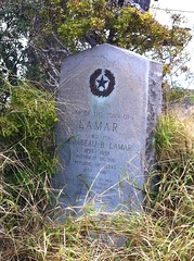
Texas Historical Marker #03018
Site of the Town of Lamar. Named for Mirabeau B. Lamar 1798-1859, President of the Republic of Texas 1838-1841. Established in 1838; made a port of entry in 1839. Sacked by Union troops Feb. 11, 1864. Survived until 1914 but never flourished. #3018
?, Rockport, TX, United States
Subjects

_plaque_01.jpg)

Texas Historical Marker #03019
Lamb County Sand Hills. A natural landmark, this chain of sand dunes extends for 130 miles and is three to five miles wide. Archeological findings show that the area was inhabited 6,000 years ago. Comanches camped in the sand hills because of wild game, vegetation, protection from the wind, and the availability of water. Spanish explorers and later Anglo-Americans used the old Indian trails that passed along the dunes. Early ranching did little damage to the area. However, in recent years, the sand hills have been destroyed by extensive farming and industrial operations. (1979) #3019
US 385, 6.2 miles South, Springlake, TX, United States
Texas Historical Marker #03020
Lamkin. Originally established 1870, one-half mile north on bands of the Leon River. Named for George Lamkin, donor of land for townsite. Business firms included general store, blacksmith shop, gin, post office and drugstore. Despite several floods and fires, pioneer merchants gamely rebuilt. Only after the flood of 1908 destroyed old Lamkin was town moved to present site. Two years later with the coming of the Cotton Belt Railroad, Lamkin developed into a shipping center for farmers and ranchers. By 1920, the town had 2 gins, a hotel, bank, produce house, lumberyard, blacksmith shop, 3 general stores, post office, 4 churches, telephone exchange and drugstore. Consolidated Public School had average attendance of over 200. Basketball team was county champion for 4 consecutive years. Annual attraction was horse and mule show. In 1922, fire destroyed a major portion of business firms. Lamkin rebuilt but failed after railroad discontinued, 1936. An often-related pioneer story was of 1869 Indian raid 2 miles east of here on Resley's Creek. The home of Mrs. Elizabeth Ewell was ransacked by 19 renegade Indians. The widow and her 2 sons were not at home but on their return were greeted by clouds of feathers from ripped mattresses. A posse drove the Indians away. (1967) #3020
?, Lamkin, TX, United States
Texas Historical Marker #03021
Moses Lapham. Near hear on October 20, 1838 Moses Lapham, a veteran of San Jacinto,and three of his companions were killed by Indians, as were seven members of a rescue party on the following day. #3021
?, San Antonio, TX, United States
Texas Historical Marker #03022
Lampasas County. Formed from Travis and Bell counties; created February 1, 1856; organized March 10, 1856; The name Lampazos, first given to the river by the Spaniards, was suggested by the many cockle-burs in the region. First settlements about 1850; first railroad, 1882; county seat, Burleson, after 1856, called Lampasas. #3022
?, Lampasas, TX, United States
Texas Historical Marker #03023
Lampasas County Courthouse Site. -- #3023
?, Lampasas, TX, United States
Texas Historical Marker #03025
Lampasas County, C.S.A.. Organized 1856; had 1028 people in 1860; favored secession by 85 to 75 vote in 1861. Sent 2 units to serve in Texas State Troops, 2nd Frontier District; one unit to 17th Texas Infantry; 2 units to 27th Brigade, Texas Militia. Also had 48 Minute Men in 6 patrols to guard home front and property of men away at war. After a week of duty, each unit returned home to aid women and children tending cattle, crops. Helped supply frontier troops and miners in Longhorn Caverns. Indians still roamed here during Civil War, stealing horses, killing hunters and others. #3025
?, Lampasas, TX, United States
Texas Historical Marker #03027
Lampasas Volunteer Fire Department. Beginning with two hose-reel companies and one hook and ladder company in late 1880's this department has been constantly on call. Has fought many serious blazes; assisted during several disastrous floods. On Christmas Eve, the big red trucks carry food and clothing to the needy. #3027
?, Lampasas, TX, United States
Texas Historical Marker #03029
Lancaster Cemetery. Thomas Lancaster (1813-1867), a farmer and rancher who came to Bell County in 1851, set aside a plot of land on the west side of Little Elm Creek for a community burial ground. Although some burials took place here before Lancaster's death in 1867, his is the oldest marked grave. There are a number of unmarked graves, as well as over 175 documented ones. A cemetery association, formed in 1977, maintains the historic graveyard. In addition to fencing the property, the organizations has improved roads on the site and erected a sign at the entrance. (1987) #3029
?, Temple, TX, United States
_plaque_01.jpg?width=250)
Texas Historical Marker #03030
Land Title Building. Pioneer architects Haggart and Sanguinet designed this brick, sandstone and cast iron building with rounded arched windows and other ornate details. It featured the first known stone carving in Fort Worth, the figure of an owl, and displayed the initials of the lawyers Ross, Head and Ross, who occupied the second floor, above the title firm. The structure is architecturally important because its style was rare in this region when it was built in 1889. Recorded Texas Historic Landmark-1977. #3030
111 W. 4th St., Fort Worth, TX, United States

Texas Historical Marker #03031
Landmark Inn. Built as a one-story home and store, about 1844, by French settler Caesar Monad. Later became Vance Inn, after top floor and bath house were added, to accommodate travelers. Civil War bullets were made of lead lining peeled off a room of the bath house, in 1860's. After 1927, Jordan T. Lawler and his sister, Ruth Lawler, natives of New Orleans, La., owned and restored inn. Recorded Texas Historic Landmark, 1965. #3031
?, Castroville, TX, United States
Texas Historical Marker #03032
Landrum House. This house stands on the 1781 Concepcion de Carricitos grant from the king of Spain to Eugenio and Bartolome Fernandez. Acquiring a part of the grant as fee for his legal services to the heirs, col. Stephen Powers of Brownsville gave the site to his daughter Frances and her husband, James Lambert Landrum. The landrums, who completed the house in 1902, had daughters: Martha, Pauline and Frances. In 1978 Frances owns and lives in the house. #3032
?, San Benito, TX, United States
Texas Historical Marker #03033
Laneri House. Italian immigrant John B. Laneri moved to Fort Worth in 1883 and became a prominent businessman and civic leader. He founded the O.B. Macaroni Company and started a private boys school unknown as Laneri College. He had this residence built in 1904 in one of the city's most prosperous neighborhoods. The brick structure features classical detailing and fine interior woodwork. Laneri occupied the house until his death in 1935. Recorded Texas Historic Landmark-1982. #3033
902 S. Jennings Ave., Fort Worth, TX, United States

Texas Historical Marker #03034
Lanes Chapel and Cemetery. Pioneer area settler Joshua McCuistion donated land at this site for a Methodist chapel to serve the community of Hollis Prairie. Completed about 1880 adjacent to a schoolhouse, it was built by John R. Lane and his sons, for whom the settlement was later named. The oldest marked grave in the church cemetery is that of Plonzo "Pompey" Cox (1840-1880). Regular worship services here were discontinued in 1960 and the Lanes Chapel Memorial Association was established to restore and maintain the building and grounds. A homecoming is held at this site each June. (1981) #3034
?, Clifton, TX, United States
Texas Historical Marker #03035
Lanius House. A native of Bonham, Texas, Clarence Lanius (1880-1947) was a cattleman with ranches in several locations across the state. By 1922 he and his wife, Myrtle (Swecker) (1880-1958), had moved into their new home here in the city's finest residential area in the early 20th century. The Lanius house is a good example of the Bungalow style of architecture popular at the time and features broad overhanging eaves that are somewhat flared. A wide porch and porte-cochere dominate the facade. Recorded Texas Historic Landmark-1985. #3035
2420 W. Adams, Fort Worth, TX, United States
Texas Historical Marker #03036
Laredo Election Riot, 1886. Annual elections for city officials, held here since 1767, were followed by rioting in 1886. Citizens were divided among two rival parties. The Guaraches, named for the Mexican Indian sandals, were led by Dario Gonzales. Raymond Martin, a French immigrant, led the Botas (boots). Shortly before the April election, a Bota city councilman was killed. Sheriff Dario Sanchez, a Bota, appointed several special deputies, and Guarache resentment flared. The April 6 election was peaceful. Bota candidates won all places except two. Against the advice of party leaders, the Botas planned a mock funeral for their defeated opponents on the evening of April 7. The humiliated Guaraches determined to stop the procession. They fired their ceremonial cannon, filled with nails and scrap iron, into the Bota parade. Both sides began shooting, and a battle ensued. U.S. soldiers, dispatched by Col. R. F. Bernard, commander at Fort McIntosh, ended the fighting. Martial law was imposed. Casualties were estimated higher than the 11 known dead. Col. Bernard blamed the violence on factions in both parties, and on lawless outsiders and renegades gathered on both sides of the border in the days preceding the election. (1976) #3036
?, Laredo, TX, United States
Texas Historical Marker #03037
The Laredo National Bank. Villa de San Agustin de Laredo, founded here by area rancher Tomas Sanchez in 1755, was an agrarian-based community for its first 125 years. The convergence of three railroad lines here in the 1880s significantly expanded business activity in Laredo and attracted many new European and Mexican immigrants to this area. These events heralded a shift to a mercantile economy and prompted San Antonio merchant John King Beretta to open a privately-owned bank in 1892. The bank prospered and was chartered by the U.S. Treasury as the Laredo National Bank in 1895. The bank's initial success was sustained by Mexican trade, local Bermuda Union production in the 1890s, and commercial activity associated with the production of oil in the area during the early 1900s. The bank continued to prosper during the Mexican Revolution (1910-1917), due partially to increased U.S. military activity in the area. By 1922 Laredo National Bank boasted $2 million in assets. Sound fiscal policies allowed the bank to emerge from the 1930's depression on solid ground. In 1979-1983 this building (former site of the Robert E. Lee and Plaza hotels) was renovated for use as the bank's headquarters. Sesquicentennial of Texas Statehood 1845-1995 #3037
?, Laredo, TX, United States
Texas Historical Marker #03038
Largest Pictograph Site in Texas. 1500 paintings by various tribes at widely differing dates are scattered along the bluff for a half mile. Most outstanding pictorial contribution of the nomadic tribes of Texas. #3038
?, Paint Rock, TX, United States

Texas Historical Marker #03039
"The Poet Ranchman" Larry Chittenden. (March 23, 1862 - Sept. 24, 1934) Author of "Cowboys' Christmas Ball" - cited for literary merit by National Folklore Society. Born in New Jersey, Chittenden first came to Texas as a sales agent. In 1884 he visited S. M. Swenson at this site; in 1887 began developing 10,000 acres of family-owned land 16 miles southwest of here. Through rough ranch life he caught spirit of the land. With publication of his "Ranch Verses" in 1893, fame was assured. He lived in Jones County for many years; gave his own library and an endowment to Anson High School. His burial place is in New Jersey. (1970) #3039
?, Stamford, TX, United States