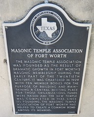
Texas Historical Marker #03247
Masonic Temple of Fort Worth. This building was constructed for the Masonic Temple Association of Fort Worth provide a single meeting place for all member bodies. Completed in 1932, it was designed by the Fort Worth architectural firm of Wiley G. Clarkson & Co. The Temple exhibits Neo-Classical styling with Art Moderne influences and features upper-story ionic columns and Monel bas-relief doors. Recorded Texas Historic Landmark-1984. #3247
1100 Henderson, Fort Worth, TX, United States
Subjects


Texas Historical Marker #03249
Matador Ranch. The Matador Cattle Company began as an open range ranch in 1879 when Henry H. Campbell, A. M. Britton, and three others bought range rights in this area. In 1882, the ranch was purchased by Scottish investors, who formed the Matador Land & Cattle Company, Ltd. The ranch utilized one and one half million acres of owned and leased range in Motley, Floyd, Dickens and Cottle counties. In 1902, the ranch acquired the 210,000 acre Alamocitas Ranch in Oldham County. Additional pastures were leased in the Dakotas, Montana and Canada. At its height the ranch owned 90,000 cattle and title to 879,000 acres of Texas land. In 1913, the Quanah, Acme and Pacific Railroad was built through the ranch in Motley County and the town of Roaring Springs was established. General managers of the ranch were Britton (1879-90), Murdo MacKenzie (1890-1911, 1923-1937), John MacBain (1912-1922), and John MacKenzie (1937-1951). The general manager's office was located first in Fort Worth and later in Trinidad and Denver, Colorado. Corporate offices were maintained in Scotland from 1882 until the ranch's liquidation in 1951. The ranch headquarters was purchased by Koch Industries, Inc. and became The Matador Cattle Company. Texas Sesquicentennial, 1836-1986 #3249
SH 70, Matador, TX, United States
Texas Historical Marker #03250
Matagorda Cemetery. One of earliest cemeteries in Texas. Founded soon after town was settled, about 1829, as part of Stephen F. Austin's colony. Marked graves numbered 650 in 1969, but interments exceed 1,000. Inscriptions on stones chronicle frontier hardships. Those buried include victims of 1862 yellow fever epidemic; soldiers of Texas Revolution War of 1812, and the Civil War; also Karankawa Indian victims. Several patriots of early Texas are buried here as well. Among them is Samuel Rhoads Fisher, a signer of the Texas Declaration of Independence. (1970) #3250
?, Matagorda, TX, United States
Subjects
Texas Historical Marker #03251
Matagorda County. Organized March 6, 1834, into the Mexican municipality of Matagorda created a county of the same name in 1836, organized in 1837. Named for the Bay on which it fronts. County seat, Matagorda 1837-1894 Bay City, since. #3251
?, Bay City, TX, United States
Texas Historical Marker #03252
Matagorda Lodge No. 7, A.F. & A.M.. One of the oldest Masonic lodges in Texas, this lodge traces its history to the Republic of Texas. A group of masons met together on June 24, 1838, and petitioned the newly created Grand Lodge of Texas for a charter to Seth Ingram as first master. From its beginning, the Matagorda Lodge was active and influential in the community's development. The first services of Christ Episcopal Church were held in the Masonic Hall. The masons operated a lending library for the town's citizens and supported local public education projects. In 1868, due to a succession of financial difficulties and the strains of the Civil War, the Matagorda Lodge was deactivated. The members maintained interest in the lodge, however, and it was finally rechartered by the grand lodge in 1911 under its original number. Many prominent Texans have been affiliated with this lodge, including local and state government officials. The lodge has counted among its members veterans of the war of 1812, the Texas Revolution, Mexican War, Civil War, World War I, World War II, Korea, and Vietnam. (1990) #3252
?, Matagorda, TX, United States
Texas Historical Marker #03253
Matagorda Methodist Church. One of the earliest Methodist churches in Texas. Founded January 6, 1839, by the Rev. Jesse Hord, a circuit rider who recorded that he came through "Black mud, a pouring down rain and a howling norther" to hold services in Matagorda. When he preached at "Early candle light" (dusk), four persons came forward to form the nucleus of the present church. The first church building was erected about 1851 but was destroyed by the great hurricane of 1854, which leveled almost every building in town. In 1869 worship was held in the county courthouse; in 1891 the present parsonage was built. In 1892 members decided they must have a proper church after being accidentally locked out of their meeting place -- the schoolhouse -- on a cold, rainy Thanksgiving Day. Long leaf yellow pine and cypress were brought in from Galveston and the present church was completed 1893. A Sunday school was soon founded by the Ladies' Aid Society. In 1927, Sunday School rooms, a kitchen, and study were built. In 1942, another hurricane and flood damaged, but did not destroy, the church. Today, though many improvements and new furnishings have been recently added, the original bible, bell, and hand-made cypress pews are still in service. (1968) #3253
?, Matagorda, TX, United States
Subjects
Texas Historical Marker #03254
Matagorda, C.S.A.. Near the mouth of the Colorado River, 20 miles to the south, is the town of Matagorda, the second most important Port of entry in early Texas. In the Civil War, center for rich farmlands and one of 8 Texas ports that blockade runners used for taking out tons of cotton while delivering to the confederacy guns, munitions, clothing and other vital goods. By reason of the declared blackade, the federals claims to hold Matagorda, yet their own ships had to refuel (even to supplies of drinking water) in New Orleans. When a blockader's crew went ashore near Matagorda, on November 20, 1862, confederates captured every man. By hit-and-run tactics, federals destroyed salt works and other propert, but found Matagorda Peninsula impossible to occupy. On December 30, 1863, C.S.A. cottonclads (ships bulwarked with cotton bales in which guns were set) moved men out of Matagorda to expel a federal unit from a beach below confederate works at Caney Creek. When troops were trying to land, a sudden norther lashed the bay and swamped their skiffs. Before the ships could pick them up, 22 men died by drowning or freezing. In the tragedy, the troop commander, Capt. E.S. Rugeley lost his own 17-year-old brother. #3254
?, Bay City, TX, United States
Texas Historical Marker #03255
Matamoros Road. Near this site, used by Indians and the Spanish before 19th century Anglo-American settlement of Texas. Path of armies, missionaries and commerce. About 330 miles long, the route varied with seasons, depending on chances to water teams pulling wagons or carts. Driest stretch was from the Nueces to the Rio Grande. The trip from San Antonio to Matamoros took 6 to 8 weeks, even when delays did not occur. Bandits were an added danger. Slow-moving wagon trains attracted robbers on fast horses. Teamsters learned to hide money in bags of grain or potatoes. They would even bore holes in cart axles, put gold in, plug each hole, cover the spot with black grease. During the Civil War, this was main artery of the cotton road, lifeline of the Confederacy. Wisps of cotton thorned into mesquite trees marked its way. A 6-mule wagon would haul up to 12 bales of cotton. A solid-wheel Mexican cart drawn by 10 oxen hauled up to 16 balees. When teams grew exhausted, bales of cotton would be thrown off and hidden, so that the teamster might pick them up later. In extremely hot, dry weather, the way would be lined with discards. Returning wagons brought guns, ammunition, cloth and other goods so much needed by the Confederacy. #3255
?, San Antonio, TX, United States
Texas Historical Marker #03256
Mathis House. John M. Mathis (1831-1922) had this home built for his family in 1868-69. Instrumental in platting the town of Rockport, he served as its first mayor in 1870. In 1880 he deeded the house to his cousin, Thomas H. Mathis (1834-1899), a leading rancher, shipper, and banker. Exhibiting Italianate, Classical, and Greek Revival details, the raised cottage features a center passage plan, arcaded basement, and entry portico with paired fluted columns. Recorded Texas Historic Landmark - 1989 #3256
621 S. Church Street, Rockport, TX, United States

Texas Historical Marker #03257
Matthews Memorial Presbyterian Church. -- #3257
Jacobs and S. 2nd, Albany, TX, United States
Texas Historical Marker #03259
Maverick. Founded in the 1870s. Named for Samuel A. Maverick (1803-1870), who came to Texas 1835. Fought in the Texas War for Independence. In Secession Convention, 1861, he was made one of the commissioners to negotiate surrender of United States troops in San Antonio. In 1853 he had land in this important ranching area. #3259
SH 158, about 13.5 mi. W of Ballinger, Ballinger, TX, United States
Subjects
Texas Historical Marker #03260
Maverick County. Created Feb. 2, 1856, from Kinney county. Organized July 13, 1871. Named for Texas Revolution veteran, signer of declaration of Independence, Texas Legislator Samuel A. Maverick (1803-1870). The county centers in an area of dairies, farming, ranching. Hard-travelled El Camino Real (path into Texas History for Louis St. Denis, Spanish Missionaries, Moses Austin and countless troops and settlers) crossed the Rio Grande near Eagle Pass, the county seat. Site of Spanish Mission ruins, military posts. Fort Duncan, now a military park, housed both U.S. and confederate troops. (1965) #3260
?, Eagle Pass, TX, United States
Subjects

Texas Historical Marker #03261
Maverick County Courthouse. A landmark of the Texas-Mexico border area. Built 1884-85, during term of county Judge Thomas Lamb, on site chosen by citizens' committee, who donated $800 toward purchase of land from R.E. Moffit. Architects: Wahrenberger and Beckman, San Antonio. Contractor: A local builder, William Hausser (1847-1919). Courthouse and a jail were erected at total cost of $20,489. This was site of celebrated Dick Duncan murder trial, 1889. Duncan, accused of killing four members of a San Saba family he was escorting to Mexico, was convicted on evidence gathered by Sheriff W.N. Cooke and Texas Rangers Ira Aten and John R. Hughes. He was sentenced to death by district Judge Winchester Kelso. Duncan appealed to state and federal courts and gained national notoriety, but was hanged in the county jail on September 18, 1891, in the only capital execution ever carried out by Maverick county. Early jail was replaced in 1949. A fine example of Victorian design, with crenelation that suggests a fortress, the courthouse is a border structure with great architectural significance. The clock tower still holds its original E. Howard works and bell. Marker dedicated in September 1971 to commemorate centennial of the organization of Maverick county. Recorded Texas Historic Landmark - 1971 #3261
?, Eagle Pass, TX, United States
Texas Historical Marker #03262
Home of Samuel Augustos Maverick. A native of South Carolina; came to San Antonio in 1835; was guide for Ben Mailam and other leaders in first attack on San Antonio by Texas Army, Dec. 1835. As Bexar delegate, Maverick signed Texas Declaration of Independence at Washington-on-Brazos, 1836. With Capt. Jack Hays' "Minute Men," he helped make San Antonio safe from Comanche Indian attacks; also joined Hays' expedition which opened California road and claimed Rio Grande as Texas' western boudnary. Twice Mayor of San Antonio; he was prisoner-of-war in Perote,Mex., for 7 months after Gen. Adrian Woll's capture of San Antonio in 1842. Was elected as Bexar representative to 7th Congress of Republic (1842) while still a prisoner at Perote. Member of committee which accepted surrender of U.S. troops and forts in Texas without bloodshed in Civil War, 1861. Was Chief Justice of Bexar County during War; served in Texas House, Senate afterwards. He married Mary Ann Adams of Tuscoloosa, Ala. They became parents of 9 children. His famous practice of letting his cattle run about unbranded gave English language the word "maverick," meaning an indepenent person, as well as unbranded animal. Texas' Maverick County and town were named in his honor. #3262
105 N. Alamo St., San Antonio, TX, United States
Subjects
Texas Historical Marker #03263
Maxdale Bridge. In July 1913, the Bell County Commissioners Court, in response to repeated flooding in this area, approved construction of a bridge at this site to provide access to Killeen for residents of the Maxdale Community. Before it was completed, however, the bridge was destroyed in a flood. The Bell County Commissioners Court contracted again with Hess & Skinner Engineers, agents for the Missouri Valley Bridge Company, to build this bridge. Completed in 1914, the Maxdale Bridge employs a Parker truss design, which allows for maximum strength at mid-span. Recorded Texas Historic Landmark - 1990 #3263
?, Killeen, TX, United States
Texas Historical Marker #03264
Maxdale Cemetery. Established in the 1860s to serve the rural community of Pleasant Grove, this cemetery is one of the oldest in Bell County. Land for the graveyard was given by Frank N. McBryde, Sr., whose 1883 application for a post office for the community resulted in the name change to Maxdale. The earliest documented grave is that of Louisa Marlar (1849-1867), although an 1863 tombstone marks the site of a grave reinterred here from another location. Others interred here include pioneer settlers and veterans of the Civil War, World War I, World War II, and Korea. (1989) #3264
?, Killeen vicinity, TX, United States

Texas Historical Marker #03265
Maxwell-Liston House. This late Queen Anne style residence was built in 1904 by Charles W. Maxwell (1850-1912). A contractor and carpenter by trade, Maxwell lived here with his wife, Katie, until 1907. The home then was sold to James Liston (d. 1917), and it remained in the Liston Family until 1941. Elements of the Queen Anne style represented in the Maxwell-Liston House include the corner turret, the wraparound porch, and the wreath and scroll decorative work in the front gables. Recorded Texas Historic Landmark-1985. #3265
712 May St., Fort Worth, TX, United States
Texas Historical Marker #03266
May-Hickey House. One of the most important early vernacular dwellings remaining in southeast Texas, this structure was built in the 1840s for the family of John Joseph May. The James Hickey family lived in the house as early as 1861 and later acquired the land and house. This finely built one-and-one-half-story home, made of hewn logs with chinking and covered with milled siding, features the distinctive open dogtrot and stone chimneys popular in early Texas. Recorded Texas Historic Landmark - 1988 #3266
?, Yoakum, TX, United States