Places, subjects, or plaques matching "data"
27 plaque matching "data"
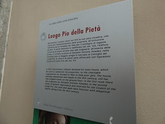
Luogo Pio della Pietà Bartolomeo Colleoni donò nel 1475 la sua casa cittadina, che usava per l'amministrazione delle proprietà , all'istituzione benefica da lui fondata nel 1466 per il sostegno di ragazza povere. In parte demolito e riedificato nel sec. XIX, l'edificio conserva al piano terreno due sale originarie: all'interno della prima, si trovano sculture di Giovanni Antonio Amadeo; nella seconda sala, di maggior pregio e riservata al Consiglio del Luogo Pio, la volta e le pareti sono affrescate con figurazioni allegoriche della fine del sec. XV.
English translation: Pius Place of Mercy Bartolomeo Colleoni gave in 1475 his town house, he used for the administration of the properties, beneficial to the institution he founded in 1466 to support poor girl. Partly demolished and rebuilt in 19th century, the building retains the original ground floor two rooms: in the first, there are sculptures by Giovanni Antonio Amadeo; in the second room, the most valuable and reserved to the Board of Pius Place, the vault and the walls are frescoed with allegorical figures of the end of the 15th century.
Via Bartolomeo Colleoni, Bergamo, Italy
Subjects

Texas Historical Marker #00144
Amarillo Helium Plant. This plant, operated by the United States Bureau of Mines, was the first to produce helium from the extensive helium resources in the Texas Panhandle. From 1929 until 1943, it furnished almost all of the world's supply of helium. Operating around the clock, the plant extracts helium by liquefying the natural gas and separating helium from it at temperatures 300 degrees below zero. The natural reserves in these fields and in extensions into adjacent states contain more than 95 percent of the world's known supply of helium. This is also the site of the world renowned research center which provides fundamental data on the production and uses of helium. Helium is used for a variety of purposes: lighter-than-air craft, low-temperature research, shielded-arc welding; and in national defense, nuclear energy programs and space exploration. (1965). #144
?, Amarillo, TX, United States
Texas Historical Marker #05868
Winkler County Discovery Well. First of 612 Wells in Hendrick Field, a very prolific, 10,000 acre west Texas oil pool. This area, called "Wildcatters' graveyard", lay on the 30,000 acre T. G. Hendrick ranch. Drillers Roy A. Westbrook & Associate leased land at 10 cents an acre. Well arrived dramatically, in great blasts of oil and rock, about midnight, Sept. 3, 1926. Its eventual depth was 3,049 feet. Total production when plugged in 1939 was 235,000 barrels. Data gathered here was vital in future drilling of El Capitan reef lime, a major oil-bearing geologic formation. (1972) #5868
SH 115, Near City Hall, Wink, TX, United States
Texas Historical Marker #10781
Sons of the Republic of Texas. On April 10, 1893, under the guidance of Francis Marion Otis Fenn, a local lodge was organized in Richmond for the benefit of male descendants of Texas Revolution veterans. The Richmond group traveled to Houston a few days later, and on April 20, 1893, a statewide organization called the Sons of the Republic of Texas was formed with 56 members. W. A. Craddock of Brenham served as first president. Although various reunions were held over the years, the organization fell inactive by World War I. In 1922, the Sons of the Republic reorganized in Houston and elected Andrew Jackson Houston, son of Gen. Sam Houston, as their president. Twelve of the 35 charter members had belonged to the 1893 organization. Male descendants of persons who had performed either civil or military service for Texas between 1820 and Jan. 1, 1846, were eligible for membership. Since the 1922 organization, the Sons of the Republic have sought to cultivate state patriotism by encouraging the observance of holidays such as Texas Independence Day (March 2) and San Jacinto Day (April 21), and by preserving historical data associated with the Revolution and Republic. Members have established museums, erected monuments, and encouraged the study of Texas history. Texas Sesquicentennial 1836 -1986. #10781
?, Houston, TX, United States

Texas Historical Marker #13266
Belgian Transit of Venus Observation Site. The year 1639 marked the first recorded observation of Venus crossing the sun. Sir Edmund Halley (1656-1742) later predicted that using data from such crossings, known as transits, scientists could precisely quantify the astronomical unit of distance and measure the size of the solar system. The transits of Venus predicatably come in pairs, eight years apart, approximately every 120 years. Scientists from around the world traveled to observation sites during the next events, in 1761 and 1769, but timing of the transits was difficult due to the "black drop effect," in which two objects against a bright background appear to blend. For more than a century, astronomers prepared for the next opportunity to record Venus' transit. Jean-Charles Houzeau (1820-1888) was a Belgian astronomer with an eclectic history. From 1859 to 1861, he worked as a surveyor in Uvalde, Texas. An abolitionist, he left Texas at the start of the Civil War. In the late 1870s, he returned to Belgium, where he became director of the Royal Observatory and planned the Belgian teams that would go to the western hemisphere to observe the December 1882 transit of Venus. He chose one site in Chile and one (22 feet east) in San Antonio. Good observations required clear skies, and San Antonio offered the chance of favorable weather, as well as good logistics for communication and transportation. A U.S. Naval Observatory team observed from a site on the grounds of nearby Fort Sam Houston. Using a heliometer, a device he had developed for the observation, Houzeau obtained 124 photographic plates of Venus silhouetted against the sun. Because of clearer conditions, the team in Chile obtained 606. The Belgian findings equaled those of larger nations, and Houzeau's decision to bring an international team to San Antonio provided the city recognition as part of astronomical history. (2005) #13266
621 Pierce Ave, San Antonio, TX, United States

ACS Chemistry for Life (R) National Historic Chemical Landmark The Keeling Curve Scripps Institution of Oceanography University of California, San Diego La Jolla, California In 1958, Charles David Keeling (1928-2005) of Scripps Institution of Oceanography began a cooperative pogram for the study of atmospheric carbon dioxide (CO2) at the newly estabilished Mauna Loa Observatory of the U.S. Weather Bureau and other sites around the world. By 1960, Keeling revealed two significant findings, reporting the first quantitative estimate of Earth's natural seasonal CO2 oscillations while also discovering a steady annual increase in CO2, the most significant greenhouse gas contributing to global climate change. Keeling advanced our understanding of mankind's impact on Earth by linking fossil fuel emissions to rising levels of CO2. His dedication to continuous and accurate measurements enabled these data to become an unequivocal record of the global rise in CO2 and an icon of atmospheric science. American Chemical Society June 12, 2015
Ritter Hall, Kennel Way, La Jolla, United States
First Weather Satellite, The. The world's 1st experimental and operational weather satellite, TIROS 1, was manufactured here by Lavelle Aircraft Corp. in 1960. Pioneering satellite TV techniques, TIROS recorded the 1st TV image from space. Its success led to improved satellites that provided key data to Meteorology.
State & Sterling Streets, Newtown, PA, United States

The Fitzroy Barometer This barometer was originally 'loaned' to mousehole in 1854 by Admiral Fitzroy, founder of the Meteorological Office. Its purpose was to provide data to the Met Office to improve storm warnings but also to give the fishermen of the village warning of pending bad weather in an attempt to reduce the loss of life so common at the time In 2009, the Meteorological Office gifted the barometer to Mousehole Harbour Authority.
South Cliff, Mousehole, United Kingdom
Dr Reg Herschy 1926-2012 Reg's pioneering contribution to river flow management in the UK and internationally provided the foundation for modern river and water resources management. His leadership and expertise, together with an abiding commitment to data accuracy remain an inspiration for current and future hydrologists.
Teddington Lock, London, United Kingdom

Ancienne Ecole polytechnique: Fondée en 1794 par la Convention, elle fut d'abord logée à l'hôtel de Lassay, aujourd'hui résidence de l'Assemblée nationale. Les élèves étaient alors externes. Napoléon1er lui attribua en 1805 les locaux des anciens collèges de Navarre (fondé en 1315), Boncourt et de Tournai. La chapelle, la sale des actes, le pavillon de théologie, qui dataient du Moyen Age, furent détruits de 1836 à 1875. En 1936, l'aménagement du pavillon Joffre a supprimé d'autres constructions du XVIIIe siècle: seul subsiste, en façade, un avant-corps de 1738. En 1977, la décentralisation a transféré l'Ecole polytechnique à Palaiseau. Ses bâtiments ont été affectés au ministére de la Recherche et de l'Espace, et au Collége de France.
English translation: Former Polytechnic School: Founded in 1794 by the Convention, it was first housed in the hotel of Lassay, now residence of the National Assembly. The students were then external. In 1805 Napoleon1 assigned him the premises of the former colleges of Navarre (founded in 1315), Boncourt and Tournai. The chapel, the dirty acts, the theological pavilion, which dates back to the Middle Ages, were destroyed from 1836 to 1875. In 1936, the construction of the Joffre Pavilion removed other 18th-century buildings: only a 1738 avant-corps remains on the façade. In 1977, decentralization transferred the Polytechnic to Palaiseau. Its buildings were assigned to the Ministry of Research and Space, and to the Collége de France. [AWS Translate]
5 rue Descartes, Paris, France

Palais Abbatial. Construit en 1586 pour le cardinal de Bourbon, chef des Ligueurs et abbé commandataire de Saint-Germain-des-Prés, ce palais est vraisemblablement dû à l'architecte Guillaume Marchant, auteur du plan et directeur des travaux. Deuxième construction en brique et pierre de Paris après l'hôtel Scipion, il préfigure le style Louis XIII. Un siècle plus tard, Guillaume Egon, cardinal landgrave de Fürstenberg, abbé de Saint-Germain, entreprend la rénovation du bâtiment qui menace ruine. Le sculpteur Pradier y eut son atelier. Restauré en 1977 par Yves Boiret, cet édifice important, le seul à être conservé entier, délivré des ajouts qui le défiguraient, témoigne de la splendeur de l'abbaye. Il abrite divers établissements rattachés à l'Institut catholique.
English translation: Abbey Palace. Built in 1586 for the Cardinal of Bourbon, Head of the Ligueurs and Abbé Commandant of Saint-Germain-des-Prés, this palace is probably due to the architect Guillaume Marchant, author of the plan and director of works. Second brick and stone construction in Paris after the Hotel Scipion, it prefigures the Louis XIII style. A century later, Guillaume Egon, landgrave cardinal of Fürstenberg, Abbé de Saint-Germain, began renovating the building that threatened to ruin. The sculptor Pradier had his workshop there. Restored in 1977 by Yves Boiret, this important building, the only one to be preserved entirely, delivered from the additions that disfigured it, testifies to the splendour of the abbey. It houses various institutions attached to the Catholic Institute. [AWS Translate]
3 rue de l'Abbaye, Paris, France
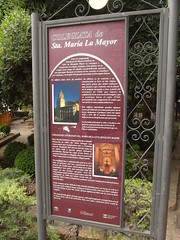
Colegiata de Sta. Maria La Mayor Una vez conquistada Ronda por los Reyes Catolicos en 1485, la Mezquita Mayor se consagro y transformo en templo cristiano. Esta iglesia, en su origen, tuvo rango de abadia con jurisdiccion especial, casi episcopal. Durante el senorio de los Austrias se constituyo en Colegiata, y en siglo XIX quedo convertida en Parroquia Mayor. El edificio tiene aires de catedral. Su fabrica es de canteria y su construccion se hizo en dos etapas; una parte gotica que debio realizarse muy pronto y que coincide con la planta de la antigua mezquita, y orta, a partir del terremoto de 1580, que supone la ampliacion de la zona norte del templo y que se prolonga hasta el siglo XVIII, presentando una conjuncion de estilos que van desde el renaceentista al barroco. Del edificio musulman quedan algunos restos del Mihrab, asi como gran parte de su traza, datandose el primero entre los siglos XIII y XIV. De el resulta interesante las influencias norteafricanas que presenta. La fachada principal se abre a la plaza con galerias superpuestas que sirvieron de palcos para presenciar los festejos que en Ella se celebraban.
English translation: Collegiate Church of St. Mary Major Ronda Once conquered by the Catholic Monarchs in 1485, the Great Mosque was consecrated and transformed into a Christian church. This church, originally had Abbey range with almost episcopal special jurisdiction. During senorio Habsburg was formed in Collegiate, and stay converted nineteenth century Parish Mayor. The building has the air of a cathedral. Its production is canteria and its construction was done in two stages; a gothic party was to be made very soon and that matches the floor of the old mosque, and Orta, from the earthquake in 1580, which is the northern extension of the temple and extending until the eighteenth century, presenting a conjunction of styles ranging from Baroque renaceentista. The Muslim building some remains of the Mihrab, as well as much of its trace, the first been dated between the thirteenth and fourteenth centuries. Of the interesting features North African influences. The main facade opens onto the square with overlapping boxes that served galleries to witness the celebrations that were held in her.
Colegiata de Santa María la Mayor - Plaza Duquesa de Parcent , Ronda, Spain
Subjects
Fontaine des Neuf Canons Le cours Mirabeau fut construit sur l'antique route d'Arles à l'Italie, qui passait au pied des remparts de la ville d'Aix. Une servitude datant du 12e siècle établissait à Aix un abreuvoir où les moutons de la Crau venaient se désaltérer dans leur transhumance vers les Alpes. Construite en 1691, cette fontaine repenait cette fonction, comme le montre une margelle surbaissée, à la taille des moutons et un bassin cruciforme aux bras allongés permettant à l'origine de faire boire de nombreux animaux en même temps. Deux des bras du bassin furent tronqués pour faciliter la circulation automobile. La fontaine crache de l'eau par neuf canons, répartis en deux vasques superposées plus un au sommet, pour en augmenter le débit. Elle est alimentée par l'eau de la ville.
English translation: Fountain of the Nine Canons The Mirabeau River was built on the ancient road from Arles to Italy, which passed at the foot of the walls of the city of Aix. A bondage dating from the 12th century established in Aix a watering place where the sheep of the Crau came to desalinate in their transhumance towards the Alps. Built in 1691, this fountain reconsidered this function, as shown by a lowered margin, the size of the sheep and a cruciform basin with elongated arms, which originally allowed many animals to drink at the same time. Two of the pelvis's arms were truncated to facilitate vehicular traffic. The fountain spits water by nine cannons, divided into two basins layered plus one at the top, to increase its flow. It is fed by the city's water. [AWS Translate]
La Fontaine des Neuf Canons - Cours Mirabeau, Aix-en-Provence, France
Subjects

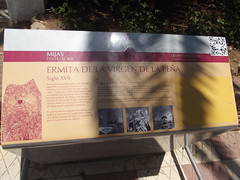
Ermita de la Virgen de la Pena Siglo XVII Se trata de una ermita cueva, que data del siglo XVII, excavada en la roca por un hermano Carmelita entre los anos 1656 y 1682, a la que por el lado de Epistola se le ha anadido una sacristia hecha con piedra irregular tratando de simular una covacha natural. El exterior de los pies, realizado con identico material e intencion, tiene acceso de medio punto y pequena espadana. En una hornacina irregular excavada en el testero se encuentra la imagen de la Virgen de la Pena, Patrona de Mijas, la cual goza de gran devocion entre los mijenos.
English translation: Chapel of the Virgin of the Rock Shrine. 17th century It is a shrine cave, dating from the seventeenth century, carved into the rock by a brother Carmelita between the years 1656 and 1682, which by the side of Epistola has added a sacristy made with irregular stone trying to simulate a Natural hovel. The outside of the foot, made with identical materials and intention, has access and small semicircular espadana. In a niche carved into the irregular headwall is the image of the Virgen de la Pena, patroness of Mijas, which enjoys great devotion among the people of Mijas.
El Compas, Mijas, Spain
Subjects
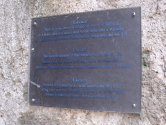
Lacaor Resti di tombe etrusche databili all'incirca 580 (?) a.C. [Lacaor Laka orei altura delle tombe; nome dato a Malcesine dal famoso arcidiacono Pacifico nel suo testamento dell’844 d.C.]
English translation:
Castello Scaligero, Malcesine, Italy
Subjects

Caesari Guardato A Philippo III Hispano rege Inter domesticos habito, ordini alcanter a' insign ib, ornato milit Mult is heroicis gestis illustri, Ad plura etiam satis idoneo nispacerba mors intercessisset. Fabius guardatus Miles hierosolymitanus |Serniae septe frat et civitatis theani commendatarius fratri amantissimo atq;optimo
English translation: Caesar Guardato From the Spanish King Philip 3 I live in the home, alcanter order a 'badge of IB, equipment and thousands of Many heroic deeds are noble, Sufficiently competent to even more nispacerba death intervened. Fabius guardatus Miles of Jerusalem | Serniae silk brothers was Theano, the city and commendatory loving brother to work, the best
Sorrento Cathedral, Corsa Italia, Sorrento, Italy

I luoghi della repubblica sociale Italiana Palazzo della Magnifica Patria Il prestigioso palazoo fu sede, a datare dal 1580, degli organi di governo della Comunità di Riviera, detta Magnifica Patria. Durante la R.S.I. (1943- '45) l'edificio ospitò l'Ufficio Interpreti mentre oggi vi trova sede il Municipio cittadino.
English translation:
Piazza Vittoria, Salò, Italy
Subjects
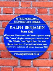
Ralph Benjamin born 1922. Electronic Command-and-Control Systems 1946, The 'mouse' display-to-computer interface 1947, The World's first Digital Data New 1947, Radar detection of buried landmines 1995, Microwave detection of breast tumours 2006.
Engineers Walk, Anchor Road, Bristol, United Kingdom
Subjects
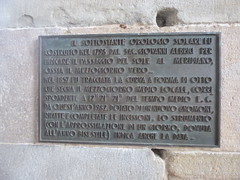
Il Sottosatante Orologio Solare fu costruito nel 1798 dal sac, Giovanni Albrici per indicare il Passaggio del Sole al Meridiano, ossia il Mezzogiorno Vero - nel 1857 fu tracciata la curva a forma di otto che segna il Mezzogiorno Medio Locale, corri spondente a 12H 21M 21S del tempo medio E.C. da quest' anno 1982, dotato di un nuovo gnomone, rifatte e completate le incisioni, lo strumento (con l'approssimazione di un Giorno, dovuta all' anno bisestile) indica anche la data.
English translation: The Sottosatante Sundial was built in 1798 by Rev. John Albrici to indicate the passage of the Sun at Meridian, ie the South Vero - in 1857 was drawn the curve in eight form that marks the South Middle Local, run ponding to 12H 21M 21S the average time E.C. from this year '1982 features a new gnomon, rebuilt and completed the incisions, the instrument (to an accuracy of a day, due to' leap year) also indicates the date.
Palazzo della Ragione - Piazza Vecchia, Bergamo, Italy
Subjects
W.E.B. Du Bois (1868-1963). African American scholar, educator, and activist. A founder of the NAACP. From 1896-1897, he lived in the College Settlement House at 617 Carver (Rodman) St. while collecting data for his classic study, published in 1899, "The Philadelphia Negro."
NW corner, S 6th & Rodman Sts., Philadelphia, PA, United States
Subjects


An dieser Stelle stand bis zum Frühjahr 1967 das ehemalige Rathaus der Gemeinde Langenhagen. Errichtet wurde das Gebäude um 1890 als Wohnhaus des Ziegeleibesitzers Heddenhausen; im Volksmund als „Villa Heddenhausen“ bezeichnet. Ein zweigeschossiger Mauerziegelbau mit Sandsteingewänden an Fenster und Eingangstür und mit ausgebautem Dachgeschoss. 1919 erwarb Langenhagen unter Gemeindevorsteher Wilhelm Weirich das Gebäude und nutzte es von da an als „Gemeindehaus“ (Rathaus). Das Erdgeschoss beherbergte die Kreissparkasse, außerdem war hier das Standesamt untergebracht. Mit dem Zusammenschluss der Gemeinden Brink und Langenhagen zur neuen Großgemeinde Langenhagen am 1. April 1938, zog die Gemeindeverwaltung in das ehemalige Brinker Rathaus am Langenforther Platz. Die Sparkasse wie auch das Standesamt verblieben in ihren Räumen, ebenso wie die im Obergeschoss schon damals vorhandene Gemeindebibliothek. Die freigewordenen Räume wurden als Jugendheim genutzt. Daneben entstand ein kleiner Festsaal mit Bühne für Veranstaltungen. Nach dem Abbruch des Gebäudes im Jahr 1967 errichtete die Sparkasse des Landkreises Hannover an diesem Standort einen Neubau für die Filialdirektion mit einem Kundenzentrum, Büroräumen und dem Rechenzentrum..
English translation: Until the spring of 1967, the former town hall of the municipality of Langenhagen stood at this point. The building was built around 1890 as the home of the brick owner Heddenhausen; popularly referred to as “Villa Heddenhausen”. A two-storey brick building with sandstone walls on the window and entrance door and with an extended attic. In 1919, Langenhagen acquired the building under the head of the municipality Wilhelm Weirich and used it from then on as a “community house” (town hall). The ground floor housed the Kreissparkasse, and the registry office was also housed here. With the merger of the municipalities of Brink and Langenhagen to form the new large municipality of Langenhagen on 1 April 1938, the municipal administration moved to the former town hall of Brink on Langenforther Platz. The Sparkasse as well as the registry office remained in their rooms, as did the municipal library on the upper floor already at that time. The vacated rooms were used as a youth hostel. In addition, a small banquet hall with stage for events was created. Following the demolition of the building in 1967, the Sparkasse of the district of Hannover erected a new building for the branch management with a customer center, office space and the data center. [AWS Translate]
Walsroder Straße 142, Langenhagen, Germany

Vom Herbst 1969 bis zum Frühjahr 1970 wurden Verhüttungsplätze und Holzkohlen-Meiler in der Wietzeaue zwischen Langenhagen und Isernhagen erforscht. Die nebenstehende Karte zeigt die damals aufgefundenen Schlackenplätze (schwarze Flächen)und Meiler (punktiert) übertragen auf das aktuelle Kartenbild der Stadtkarte. Die durch Kiesabbau entstandenen Seen gab es 1970 noch nicht. Im Gebiet gefundene Scherben datierbarer Tongefäße belegen den Zeitraum der Verhüttung des Raseneisensteins. Sie erfolgte in der Zeit vom 12. Jahrhundert bis zum Ende des 16. Jahrhunderts. Der Eindruck dichter Lage der Fundplätze im Kartenbild täuscht wegen dieses langen Zeitraums. Es waren immer nur einzelne Schmelzöfen in Betrieb. Aufgrund der Befunde nahmen die untersuchenden Wissenschaftler an, dass einfache Rennöfen verwendet wurden. Spuren von effektiveren Verhüttungsmethoden konnten nicht gefunden werden. Im Rahmen der Untersuchungen wurde auch erforscht, welche Gehölze in den Meilern zur erforderlichen Holzkohle verschwelt wurden. Es waren hauptsächlich Birke und Erle; Hasel, Hainbuche und Eiche kamen erst in zweiter Linie vor. Für die Gewinnung von 1 kg Eisen brauchte man bis zu 30 kg Holzkohle. Die damals häufig überschwemmte Wietzeaue muss man sich als mageren Niederwald vorstellen, der durch die Holzkohlengewinnung zudem mehr und mehr zerstört wurde. In der frühen Neuzeit wurde die Eisenschmelze wegen dieser „Waldverwüstung“ verboten. Von weiter entfernten Standorten wurde wahrscheinlich kein Holz herangefahren. Bei rund 500 Jahren Eisenverhüttung und nur 375 gefundenen Meilerstätten war das nicht unbedingt erforderlich.
English translation: From autumn 1969 to spring 1970, smelting sites and charcoal meats were explored in the Wietzeaue between Langenhagen and Isernhagen. The adjacent map shows the slag places (black areas) and Meiler (dotted) found at that time transferred to the current map image of the city map. The lakes created by gravel mining did not exist in 1970. Shards of datable clay vessels found in the area cover the period of smelting of the lawn iron stone. It took place in the period from the 12th century to the end of the 16th century. The impression of the dense location of the finds in the map image is deceptive because of this long period of time. Only single melting furnaces were in operation. Based on the findings, the investigating scientists assumed that simple racing furnaces were used. Traces of more effective smelting methods could not be found. In the course of the investigations, it was also investigated which woody plants were fused into the necessary charcoal. They were mainly birch and alder; hazel, hornbeam and oak were only found in second line. The extraction of 1 kg of iron required up to 30 kg of charcoal. The Wietzeaue, which was often flooded at that time, must be imagined as a meager lowforest, which was more and more destroyed by the coal extraction. In the early modern period, iron melting was banned because of this “forest devastation”. No wood has probably been approached from more distant locations. With around 500 years of iron smelting and only 375 mil sites found, this was not absolutely necessary. [AWS Translate]
süd-östlich des Wietzesees, Langenhagen, Germany

Am 31. März 1875 in Zellerfeld (Harz) geboren, kam Wilhelm Hirte mit acht Jahren nach Engelbostel. Hier absolvierte er seine Schulzeit und wurde in der Martinskirche konfirmiert. 1906 heiratete er Caroline Louise Ida Nebel aus Engelbostel. Ida Hirtes Bruder betrieb in der Straße Alt Engelbostel ein Lebensmittelgeschäft. Dieses übernahmen Hirtes 1926 und führten es bis 1956. Bereits in den 30er Jahren trug Wilhelm Hirte Daten und Informationen für eine Engelbosteler Dorfchronik zusammen. Hierbei wurde er von Lehrer Heinrich Hornbostel und Fritz Hanebuth unterstützt. Diese Dorfchronik, in deutscher Steilschrift verfasst, beleuchtet historische Ereignisse, beschreibt die Dorfentwicklung und zeigt an Hand von Fotos das dörfliche Leben. Hirte war aufmerksamer Beobachter, politisch interessiert und arbeitete mehrere Jahre als Beigeordneter im Gemeindeausschuss. Mit Gleichgesinnten gründete er 1936 die Engelbosteler Ortsgruppe des Heimatbundes und übernahm den Vorsitz. Anfang der 50er Jahre arbeitete Hirte an einer Höfechronik und beschrieb hier in der Reihenfolge der Nummerierung der Hofstellen die Besitzer und deren Vorfahren, die Gebäude, Anbauflächen und Ackerfrüchte sowie sonstige Erwerbszweige. Mitarbeiter des Stadtarchivs haben den handschriftlichen Urtext in Maschinenschrift übertragen, um die Dorf- und Höfechronik in heute lesbarer Form zu erhalten. Auch bei der Erarbeitung des Entwurfs für ein Gemeindewappen wirkte Hirte mit. Die wesentlichen Entwurfselemente gehen auf die von ihm vorgeschlagenen Symbole zurück. 1950 organisierte er für Engelbostel die 900-Jahrfeier, an der auch die Kaisertochter Viktoria Luise teilnahm. Für sein ehrenamtliches Wirken wurde Wilhelm Hirte am 31. März 1955 die Ehrenbürgerschaft der Gemeinde Engelbostel verliehen. Wilhelm Hirte starb am 12. Dezember 1957. In Würdigung seiner Verdienste benannte die Gemeinde 1962 die Verbindung zwischen der Heidestraße und der Straße Am Spritzenhaus „Wilhelm-Hirte-Straße“.
English translation: Born on 31 March 1875 in Zellerfeld (Harz), Wilhelm Hirte came to Engelbostel at the age of eight. In 1906 he married Caroline Louise Ida Nebel from Engelbostel. Ida Hirte's brother ran a grocery store in Alt Engelbostel street. This was taken over by the shepherd in 1926 and kept it until 1956. Already in the 1930s Wilhelm Hirte gathered data and information for an Engelbosteler village chronicle. He was supported by teachers Heinrich Hornbostel and Fritz Hanebuth. This village chronicle, written in German, illuminates historical events, describes the development of the village and shows the village's life using photographs. Shepherd was an attentive observer, politically interested and worked as an associate in the municipal committee for several years. With like-minded people, he founded the Engelbosteler local group of the Heimatbund in 1936 and took over the chairmanship. In the early 1950s, the shepherd worked on a court chronicle, describing the owners and their ancestors, buildings, crops and other branches of activity in the order of numbering the farms. Employees of the Stadtarchiv have transferred the handwritten original text in typed form to preserve the village and court chronicle in today's readable form. Shepherd also took part in the elaboration of the design for a municipal coat of arms. The essential design elements go back to the symbols he proposed. In 1950 he organized the 900th anniversary for Engelbostel, in which the imperial daughter Viktoria Luise also participated. On 31 March 1955, Wilhelm Hirte was awarded the honorary citizenship of the municipality of Engelbostel for his volunteer work. Wilhelm Hirte died on 12 December 1957. In recognition of his merits, the municipality named the connection between Heidestraße and Am Spritzenhaus “Wilhelm-Hirte-Straße” in 1962. [AWS Translate]
Wilhelm-Hirte-Straße / Alt Engelbostel, Langenhagen, Germany
Потомкам чтобы помнили! 22 июня 1941 года в 03:30 на этом месте (г. Кибартай, Литовская Советская Социалистическая Республика), охраняя Государственную границу, первыми приняли удар фашистских войск пограничники 106 Таурагского пограничного отряда войск НКВД СССР: 4-я пограничная комендатура – по штату 54, по списку - 52 пограничника. Комендант пограничной комендатуры – капитан Еременко Иван Моисеевич. 15-я линейная застава – по штату 63, по списку 61 пограничник. Начальник заставы – лейтенант Григорьев Иван Ильич. 4-я резервная пограничная застава – по штату 63, данных о составе в архиве нет. Начальник заставы лейтенант Красько Николай Гаврилович. контрольно-пропускной пункт «Вирбалис», данных о составе в архиве нет. Начальник КПП капитан Волков Георгий Иванович. К исходу первых суток войны из окружения вышло 6 пограничников: старший лейтенант Нехаев (тяжело ранен), лейтенант Воробьев (ранен), сержант Токарев, сержант Смирнов, сержант Пелин, рядовой Норкин (ранен). Вечная память пограничникам, погибшим на границе в июне 1941 года. Помним, гордимся!
English translation: For descendants to remember! June 22, 1941 at 3:30 at this place (St. Kibartai, Lithuanian Soviet Socialist Republic), guarding the State border, was the first to take the blow of fascist troops border guards of the 106 Tauragsky border detachment of the troops of the NKVD of the USSR: The 4th Border Commandant's Office - state 54, according to the list - 52 border guards. Commandant of the Border Commandant's Office is Captain Eremenko Ivan Moiseyevich. The 15th line outpost is 63 state, 61 border guards are on the list. The head of the outpost is Lieutenant Ivan Ilyich Grigoryev. 4th Reserve Border Outpost — for state 63, there is no data on the composition in the archive. The head of the outpost, Lieutenant Krasko Nikolai Gavrilovich. Virbalis checkpoint, there is no data on the composition in the archive. Head of the checkpoint captain Georgy Volkov. By the end of the first days of the war, 6 border guards left the encirclement: Senior Lieutenant Nekhaev (seriously wounded), Lieutenant Vorobyov (wounded), Sergeant Tokarev, Sergeant Smirnov, Sergeant Pelin, Private Norkin (wounded). Eternal memory of border guards who died on the border in June 1941. We remember, we are proud! [AWS Translate]
северо-западнее пересечения ул. Калининградской и Красноармейской, Калининградская область, Нестеровский городской округ, п. Чернышевское, Russia

ამ სახლში 1962 - 1976 წლებში ცხოვრობდა სახელოვანი ქართველი მწერალი ჭაბუა ამირეჯიბი ამავე სახლში მან დაწერა რომანი "დათა თუთაშხია"
English translation: The famous Georgian writer Chabua Amirejibi lived in this house in 1962-1976 In the same house he wrote the novel “Data Tutashkhia” [AWS Translate]
35b Alexander Kazbegi Avenue, Tbilisi, Georgia

ČOHKKÁNGEAĐGI, ISTUMAKIVI, SEATING STONE 90° 03` 39,6`` N 27° 52` 51,5`` E EUREF Eanamihtidanlágádus kártii olles Suoma Meahccediehtovuđđui 1992-2007. Kártenbargu nogai dán Njuorggáma Čohkkángeađggi viidodahkii. Maanmittauslaitos kartoitti koko Suomen Maastotietokantaan 1992-2007. Kartoitustyö päättyi tällä Nuorgamin Istumakiven alueella. The National Land Survey charted the entire country of Finland into the Topographic database in 1992-2007. The charting work ended here in the area of the Nuorgam seating stone.
English translation: ČOHKKÁNGEAĐGI, SEATING STONE 90° 03` 39.6`` N 27° 52` 51.5``E EUREF Eanamihtidanlágádus kártii olles Suoma Meahccediehtovuđui 1992-2007. Kártenbargu nogai dán Njuorggáma Čohkkángeađggi junodahkii. The National Surveying Institute mapped the whole of Finland to the Maastodatabase 1992-2007. The mapping work ended in this area of Nuorgam Istumakive. The National Land Survey charted the entire country of Finland into the Topology database in 1992-2007. The charting work ended here in the area of the Nuorgam seating stone. [AWS Translate]
, Nuorgam, Finland

დავით (დათა) ვაჩნაძე - ქართველი პოლიტიკური, საზოგადო და სამხედრო მოღვაწე, საქართველოს ეროვნულ-დემოკრატიული პარტიის ერთ-ერთი დამაარსებელი და საქართველოს დამოუკიდებლობისთვის მებრძოლი. 1917 წლის 5 ნოემბერს, ამ სახლში, დავით ვაჩნაძის ბინაზე, შედგა ქართველ პოლიტიკოსთა საიდუმლო შეხვედრა, რომელშიც მონაწილეობა მიიღეს ნოე ჟორდანიამ, ევგენი გეგეჭკორმა, იოსებ გედევანიშვილმა, დავით ვაჩნაძემ და გერმანიიდან კონსპირაციულად ჩამოსულმა მიხეილ წერეთელმა. ამ შეხვედრაზე გადაწყდა საქართველოს დამოუკიდებლობის გამოცხადება და პირველ პრეზიდენტად ნოე ჟორდანიას დასახელება.
English translation: Davit (Data) Vachnadze - Georgian political, public and Military figure, National Democratic Republic of Georgia One of the founders of the party and Georgia Fighter for independence. On November 5, 1917, this Georgian Politicians Gathered at Davit Vachnadze's Apartment A secret meeting attended by Nov. Zhordaniya, Evgeni Gegechkor, Ioseb Gedevanishvili, David Vachnadze and Mikheil, who secretly arrived from Germany Tsereteli. At this meeting, it was decided that Georgia Declaration of Independence and as First President Noah Name of Jordan. [AWS Translate]
34 Mikheil Zandukeli Street, Tbilisi, Georgia