
Texas Historical Marker #00310
Barron Field. One of three World War I fight training centers in the Ft. Worth area, Taliaferro Field No. 2 was built on this site in Nov. 1917. First used by Canadian cadets, it was occupied in April 1918 by American military units. In May, the facility was renamed Barron Field for Cadet Robert J. Barron, who was killed at another flying school. Covering over 600 acres, the camp housed as many as 150 officers and 900 enlisted men. Barron Field sent six Air Squadrons to France before the war ended, Nov. 11, 1918. The training facility closed in 1921, and today only the munitions building remains. (1976) #310
Oak Grove Rd. and Everman Rd., Everman, TX, United States
Texas Historical Marker #00311
Barrow Ranch House. (RTHL medallion - no text) #311
8900 N. County Road West (FM 1882), Odessa, TX, United States
Texas Historical Marker #00312
Bartels-Wirtz House. Distinctions of this Victorian cottage: gable window with star tracery, decorative bargeboard, carpenter's lace. Stained glass entrance doors are duplicated at back of the front hall. Anton Bartles, from Aldenburg, North Germany, came here in 1869; built this house about 1886; was an Alderman, 1889. Later owners have included the Will Wirtz family in 1920s and 30s; Felix Fehrenkamp; Mrs. Isabel Moeller. RTHL 1973 #312
1216 Live Oak St., Columbus, TX, United States
Texas Historical Marker #00313
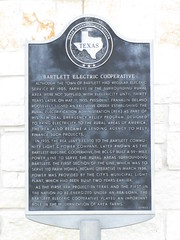
Bartlett Electric Cooperative. Although the town of Bartlett had regular electric service by 1905, farmers in the surrounding rural area were not supplied with electricity until thirty years later. On May 11, 1935, President Franklin Delano Roosevelt signed an executive order establishing the Rural Electrification Administration (REA) as part of his New Deal emergency relief program. Designed to bring electricity to the rural areas of America, the REA also became a lending agency to help finance such projects. In 1935, the REA lent $33,000 to the Bartlett Community Light & Power Company. Later known as the Bartlett Electric Cooperative, the BCL&P built a 59-mile power line to serve the rural areas surrounding Bartlett. The first section of the line, which was to serve 110 farm homes, became operative in March 1936. Power was provided by the city's municipal light plant, which had been built two years earlier. As the first REA project in Texas and the first in the nation to be enegized under an REA loan, the Bartlett Electric Cooperative played an important role in the modernization of area farms. (1985) #313
27492 SH 95, Bartlett, TX, United States
Texas Historical Marker #00314
Bartlett Grammar School. By the early 1900s Bartlett had become the railroad center of a prosperous cotton growing region. In 1903 the Bartlett Independent School District was created. By 1906-07 the 5-room schoolhouse here proved inadequate to house the district's expanding student enrollment. Bartlett enlarged the district's tax base and passed a bond election, and in 1908-09 a new multi-wing brick building, designed by noted Austin architect A.O. Watson, was built here. When a new high school was erected in 1917, the facility at this site became an elementary/grammar school. The school closed in 1988. (1994) #314
300 W. Bell St., Bartlett, TX, United States
Texas Historical Marker #00315
City of Bartlett. Settlers began moving to this area in the 1830s, when Texas was a republic, but the town of Bartlett was not established until the 1870s. The founders were J. Edward Pietzsch and Capt. John T. Bartlett, for whom the community was named. In 1882 the railroad was extended to Bartlett, making the city a major regional cotton center. Incorporated in 1890, the city is located on the Williamson-Bell county line, which divides several homes and commercial buildings. Today Bartlett continues to serve as a trade center for the surrounding agricultural district. (1981) #315
140 W. Clark St., Bartlett, TX, United States
Texas Historical Marker #00316
Home of Wellborn Barton. Home of Wellborn Barton 1821-1883; Pioneer physician of this region. For many years a trustee of Salado College, built 1866. (John Hendrickson, Contractor) Old military road and Chisholm cattle trail passed here. #316
?, Salado, TX, United States
Texas Historical Marker #00317
Battle Cemetery and Community. Established about 1880, the Battle community was named for local landowner Nicholas W. Battle (1820-1905). By the 1890s a town had developed, including a school, post office, business, homes, and churches. A cemetery was established on land acquired from Alexnder and Kenneth McLennan. The earliest documented grave dates to 1888. Following the building of the International and Great Northern Railroad line about 1901, the town began to decline. The Battle Cemetery stands as a memorial to the area's pioneers. #317
?, Mart, TX, United States
Texas Historical Marker #00318
Battle Island. Here in 1826, a company of volunteers commanded by Captain Aylett C. Buckner almost exterminated a band of Karankawa Indians who had murdered several families on Lower Caney. #318
?, Matagorda, TX, United States
Texas Historical Marker #00319
Battle of Adobe Walls. Fifteen miles to the site of the BATTLE OF ADOBE WALLS Fought on November 25, 1864 between Kiowa and Comanche Indians and United States troops commanded by Colonel Christopher Carson, 1809-1868. This was "Kit" Carson's last fight. (1936) #319
?, Borger, TX, United States
Texas Historical Marker #00320
Battle of Adobe Walls. Was fought here November 25, 1864, when Colonel Christopher (Kit) Carson (1809-1868) with a few companies of United States troops under the protection of the Adobe Walls attacked a band of hostile Kiowa and Commanche Indians and killed over 60 braves. This was "Kit" Carson's last fight. (1936) #320
?, Stinnett, TX, United States
Texas Historical Marker #00321
Battle of Agua Dulce. During the Texas Revolution, Dr. James Grant (1793-1836), a Scottish-born physician, and Francis W. Johnson (1799-1884) recruited an army of volunteers to invade Mexico and capture the town of Matamoros. After Sam Houston expressed disapproval of the poorly-organized venture, many recruits left the expedition before it reached the settlement of San Patricio along the Nueces River in January 1836. Mexican general Santa Anna, who was organizing an army to attack Texan forces at the Alamo in San Antonio, discovered the Matamoros plan and dispatched General Jose Urrea to stop the advancing expedition. Urrea's cavalry, reinforced with 300 infantrymen, crossed the Rio Grande on February 16. Meanwhile, Grant and Johnson divided their troops to hunt for horses. Johnson's men were camped at San Patricio when Urrea attacked on the morning of February 27. Johnson and 4 others escaped, while 18 texans were killed and 32 captured. On March 2, Urrea's soldiers surprised Grant's company at Agua Dulce Creek (3.25 miles northwest). Grant was among the 12 Texans killed; 6 were taken prisoner, and 6 escaped. The brief skirmish occurred on the same day the Texas Declaration of Independence was signed at Washington on the Brazos. #321
SH 44, E side of Agua Dulce, Agua Dulce, TX, United States

Texas Historical Marker #00322
Battle of Coleto and Goliad Massacre. After the fall of the Alamo, March 6, 1836, Colonel James Walker Fannin, with about 400 soldiers, mostly volunteers from the United States in the Texas War for Independence, was ordered by Texas General Sam Houston to retreat from Goliad to Victoria. March 19, the heavy Mexican force of General Urrea surrounded the withdrawing Texas contingent near Coleto Creek, and bitter fighting ensued. Fannin's volunteers hurled back the assaults of the Mexican force. On the following day, faced with several times their number, the Texans surrendered in the belief they would be treated as prisoners of war of a civilized nation. After removal to Goliad, the Fannin men were marched out and massacred on Palm Sunday under orders of Santa Anna, the general of the Mexican armies. Thus dictator Santa Anna added another infamy to that of the Alamo and gave to the men who saved Texas at San Jacinto their battle cry, "Remember the Alamo, Remember Goliad". The memorial to Fannin and his men is near Goliad. (1974) #322
?, Fannin, TX, United States

Texas Historical Marker #00323
Battle of La Bolsa. In 1859 and early 1860 a series of raids on Texas settlements led by Juan N. Cortina (1824-1894) led to skirmishes with companies of Texas Rangers and U.S. soldiers. These conflicts became known as the Cortina War. On February 4, 1860, a battle occurred at La Bolsa Bend (ca. 1 mi. S.) between Cortina's raiders and Captain John S. "Rip" Ford's Texas Rangers. The Rangers successfully defended the riverboat "Ranchero", traveling downstream from Rio Grande City, from an attack by Cortina's band. Cortina escaped into Mexico and later became a general in the Mexican Army. #323
?, Progreso, TX, United States

Texas Historical Marker #00324
Battle of North Fork of Red River. On Sept. 29, 1872, Col. Ranald S. MacKenzie (1840-89) found in this area a 262-tepee village of Comanches defying treaties that sought to confine them on Indian Territory reservations. MacKenzie's 231 U.S. Cavalry and Infantrymen captured the village in half an hour and routed Chief Mow-Way's warriors, who made a desperate resistance from sheltering creek banks. That night the Indians succeeded in recapturing their horses from an army guard detail. This taught MacKenzie a lesson that led to his eventual victory in the 1874 campaign to subdue the Indians. #324
?, Lefors, TX, United States
Texas Historical Marker #00325
George Campbell Childress. Erected by the State of Texas in Memory of George Campbell Childress, co-author and signer of the Texas Declaration of Independence. Born at Nashville, Tennessee, January 8, 1804; died at Galveston, Texas, October 6, 1841. #325
?, Galveston, TX, United States
Subjects

Texas Historical Marker #00326
Thomas Chubb House. This two-story Greek revival residence was constructed in the 1850s. During the Civil War it was the home of Commodore Thomas Chubb (1811-1890), a veteran of the Texas Revolution. Captured by Union naval forces on Galveston Bay, he returned to the city following the war and served as the port's harbor master. Later owners of the house include wholesaler John C. Wallis and Galveston district attorney and political leader Walter Gresham. Recorded Texas Historic Landmark - 1980 #326
1417 Sealy, Galveston, TX, United States

Texas Historical Marker #00327
Battle of Palmito Ranch. The last land engagement of the Civil War was fought near this site on May 12-13, 1865, thirty-four days after Robert E. Lee surrendered at Appomattox. Col. Theodore H. Barrett commanded Federal troops on Brazos Island 12 miles to the east. The Confederates occupied Fort Brown 12 miles to the west, commanded by Gen. James E. Slaughter and Col. John S. (Rip) Ford, whose troops had captured Fort Brown from the Federals in 1864. Ordered to recapture the fort, Lt. Col. David Branson and 300 men advanced from Brazos Island. They won a skirmish with Confederate pickets on May 12. Barrett reinforced Branson's troops with 200 men on May 13 and renewed the march to Fort Brown. Confederate cavalry held the Federals in check until Ford arrived with reinforcements that afternoon. Ford's artillery advanced and fired on the northern end of the Federal line while the cavalry charged. The Confederate right charged the southern end of the Federal line and captured part of the Union infantry. Barrett ordered a retreat toward the U.S. position on Brazos Island. While the Confederates reported no fatalities in the Battle of Palmito Ranch, the Union forces reported four officers and 111 men killed, wounded or missing. #327
?, Brownsville, TX, United States

Texas Historical Marker #00328
Battle of Resaca de la Palma. Was fought here May 9, 1846; And the defeat of the Mexican Army under General Mariano Arista by the United States troops under General Zachary Taylor made good the claim of Texas to the territory between the Nueces and the Rio Grande #328
?, Brownsville, TX, United States
Texas Historical Marker #00329
Battle of Rosillo. In this vicinity the Battle of Rosillo was fought on March 28, 1813. Here the "Republican Army of the North" composed of Anglo-Americans, Mexicans and Indians defeated, with heavy loss of life, Spanish Royalists troops commanded by Manuel de Salcedo, Governor of Texas. The prisoners of war were brutally murdered shortly afterwards by order of Colonel Bernardo Gutierrez. (1936) #329
4226 SE Military Drive, San Antonio, TX, United States