.jpg)

Texas Historical Marker #00186
Arcadius Steinle House. A native of Hettingen, Prussia, and a mason by trade, Arcadius Steinle emigrated to the U.S. in 1844 and moved to Castroville the next year. In 1847, he wed Marie Ann Dreyer and began construction of this home, where they reared six children. Arcadius died in 1858, and in 1858 Marie wed his brother, Franz. To the union were born five more children. The home later passed to son Henry Steinle, and it remained in the family until 1946. Built in phases to accommodate the growing family, it is a vernacular, side-gable house of stucco over rubble stone and a rear ell of timber frame and stone. Features include a central entry flanked by paired windows. Recorded Texas Historic Landmark-1962 #186
1416 Florella St, Castroville, TX, United States

Texas Historical Marker #00187
Archeological Sites at Mackenzie Reservoir and Tule Canyon. Before this area was covered by Mackenzie Reservior, evidence of human occupancy was found at 77 recorded archeological sites. The earliest artifacts date back 10,000 years to a bison kill. Prehistoric occupancy is indicated by burial sites, shallow hearths, and stone tools. Gun flints, glass beads, and metal objects confirm 18th century European contact. By 1874 Colonel Ranald S. Mackenzie's 4th Cavalry had driven the Indians from the Tule Canyon area which had been a lush grazing ground for buffalo and antelope. (1979) Incise in base: Marker Sponsor: Briscoe County Historical Commission - 1979 #187
?, Silverton, TX, United States

Texas Historical Marker #00188
Archer City Methodist Church. This congregation began as a mission in 1880, the same year Archer City was organized. The earliest pastors, including the Rev. D. D. Duncan and the Rev. I. N. Crutchfield, were circuit riders who also served neighboring counties. Members of Archer City Methodist Church constructed their first sanctuary in 1889 and built new facilities in later years as they grew in numbers. The church became a full-time, self-supporting member of the North Texas Conference in 1912. Throughout its history the congregation has provided significant service to the community. (1985) #188
224 S. Center, Archer City, TX, United States
Texas Historical Marker #00189
Archer County. A part of the Peters Grant, 1841; Created January 22, 1858; Organized July 27, 1880; Named in honor of Dr. Branch Tanner Archer 1790-1856; Texas Commissioner to the United States, 1835, Member of Congress, Secretary of War of the Republic of Texas. First permanent settlement, 1874; First railroad, 1890; Archer City, the county seat. (1936, 1986) #189
?, Archer City, TX, United States
Texas Historical Marker #00190
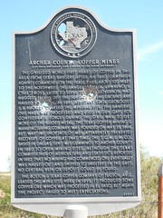
Archer County Copper Mines. The civilized world first heard of copper in this area from Texas Rangers after an 1860 campaign against Comanches on the Pease River, about 100 miles to the northwest. The Ranger Captain, Lawrence S. ("Sul") Ross, later to serve Texas as governor, had nuggets picked off the surface of the ground and hauled to Austin. In 1861, Assistant State Geologist S. B. Buckley charted the mineral site. The Rangers' ore haul was processed and used in gun caps for Confederate forces during the Civil War. To get more of the needed metal, the Texas Copper Mining & Manufacturing Company was founded on May 28, 1864, but wartime shortage of men apparently prevented recovery of copper at that time. The T.C.M.&M. Co., based in Dallas, sent W. F. Cummings to Archer County in 1880 to open mining sites. Although the Texas Commissioner of Agriculture and Statistics reported in 1882 that no mining had commenced, ore eventually was hauled out and shipped to smelters in the east. No central vein or deposit could be found. The Boston & Texas Copper Company of Tucson, Ariz., leased the mine site here in 1899. It produced some copper ore which was processed in El Paso, but again the project failed to meet expectations. (1971) #190
?, Archer City, TX, United States
Texas Historical Marker #00191
Archer County Courthouse. Courthouse, Archer County, 1891. Besides government, housed many pioneer social affairs. Dome, cupola removed, 1925. Recorded Texas Historic Landmark, 1965. #191
?, Archer City, TX, United States

Texas Historical Marker #00192
Archer County Discovery Well. M. P. Andrews No. 1, drilled in 1911, reached oil sands at 920 feet. Well first flowed oil, March, 1912, at rate of 10 barrels a day. Production in this shallow sand development area fell off when oil prices dropped, but rose after other pools in the region were tapped from 1916 to 1921. Since then, Archer County has become one of the state's most productive. The Hull-Silk-Sikes Well, 1939, opened a major field. More than 333 million barrels of crude oil have been produced by the county since 1911, with Andrews No. 1 still pumping. Recorded Texas Historic Landmark, 1967. #192
?, Archer City, TX, United States
.jpg?width=250)
Texas Historical Marker #00193
Archer County Jail. By 1909 Archer County had outgrown its original jail, a 16-foot square frame building. Construction on this larger facility was completed in Sept. 1910. The sandstone structure was designed with living quarters for the sheriff and his family on the ground floor. The second and third floors had cells and a hanging gallows which was never used. The first prisoner held in this jail was arrested for stealing a horse. More than 8,000 prisoners were jailed here until the county opened a new facility in 1974. (1985) #193
100 N. Sycamore, Archer City, TX, United States
Texas Historical Marker #00194
Archer Park. This one-block-square tract of land was deeded to the city of McAllen for use as a public park in 1917, six years after the town was incorporated. The donor, Mayor Oliver Percy Archer (1869-1930), was a prominent local businessman and civic leader. The site was officially named for him in 1933 by the McAllen Board of City Commissioners. From 1936 to 1949 the McAllen Public Library was housed in the basement area of the bandstand. The site of many community activities and celebrations, Archer Park serves as a reminder of the early days of McAllen. (1981) #194
?, McAllen, TX, United States
Texas Historical Marker #00195
Argyle. This area was first settled in the 1850s by members of the Peters Colony. In 1881 the town of Argyle was started by Galveston developer James Morrill, when a rail line was built through the area. Early residents came from neighboring settlements. Schools consolidated with Argyle included Beulah, Pilot Knob, Stoney Ridge, Lane, and parts of the Prairie Mound and Litsey Districts. An 1895 fire destroyed the business area, but it was soon rebuilt. The growth of nearby urban areas, which led to a decline before World War II, has resulted in recent population increases. (1981) #195
506 N. US 377, Argyle, TX, United States
Texas Historical Marker #00196
Argyle United Methodist Church. Organized thirteen years after the town of Argyle was founded, this church was chartered in 1894 with twenty-seven members. The first pastor was the Rev. Blueford Henry Webster, a Methodist circuit rider from Mississippi. Early worship services for the congregation were conducted in the Argyle Schoolhouse. In 1898 church trustees purchased land at this location from the Texas and Pacific railway and W. H. Abrams, company trustee. The first sanctuary, a frame structure, was built here soon afterward during the pastorate of the Rev. J. R. Atchley, who completed much of the carpentry work with the assistance of a Mr. Rhodes and several church members. Adjoining property was acquired by church trustees in 1947. A brick sanctuary was constructed here in 1969, east of the original structure, and an educational building was added in 1972. Part of a circuit for seventy-eight years, the Argyle United Methodist Church has played a significant role in the development of the town. Membership has included many prominent community leaders, and church facilities have been used for a variety of civic group meetings and public functions. (1981) #196
?, Argyle, TX, United States
Subjects

Texas Historical Marker #00197
The Argyle. Built 1859 by Charles Anderson as headquarters for a 1400-acre house ranch. Leaving San Antonio on Civil War's eve, Anderson sold to poet Hiram McLane who lived here 30 years. In 1890 at Alamo Heights' creation, a subdivider named the mansion for his native Argyllshire, Scotland. The O'Grady family, formerly of Boerne, bought the Argyle in 1893, making it famous for hospitality and food. The classic "Argyle Cook Book" was published in 1940. (1972) #197
934 Patterson Ave., San Antonio, TX, United States
Texas Historical Marker #00198
Aransas Creek Settlers. Earliest known residents were Karankawa Indians who named creek. On this stream was one of the most famous ranches in early Texas, occupied in 1805 by Don Martin de Leon, who in 1824 founded Victoria. In 1830's Irish colonists came by way of Copano Bay, settling downcreek. Anglo-Americans from older settlements, came by road and trail, stopping mainly upcreek. Stockraising, trucking and freighting provided livelihoods in the rich, new prairie land. In 1850 Patrick Fadden sold to Ft. Merrill corn and vegetables from 1835 land grant of his uncle, Father John Thomas Malloy. Fadden and W.R. Hayes freighted supplies to settlers in 1860's. Hays had early post office in his home, 1870; was county judge 1876-92. John Wilson, an 1850's upcreek settler, brought first Durham cattle to country; built one of first wooden fences, enclosing 600 acres of homesite with rough heart pine plank. On creek's north bank stood ranch of Frank O. Skidmore, founder of Skidmore, who gained fame for building first barbed wire fence and windmill in county. He promoted breeding of registered Herefords and in 1886 gave much of right-of-way to the San Antonio and Aransas Pass Railroad. (1967) #198
?, Skidmore, TX, United States
Texas Historical Marker #00199
Arlington Cemetery. Encompassing more than ten acres of land Arlington Cemetery includes within its borders several small historic graveyards, including the original old cemetery of Arlington, the W. W. McNatt Cemetery addition, the Masonic Cemetery, and the Old City Cemetery. William W. McNatt, who brought his family here from Arkansas in 1872, was a retail merchant and large scale farmer in this area. He sold the cemetery property to the Arlington Cemetery Society in 1899. Another group, the Arlington Cemetery Association, was chartered in 1923 and maintained the graveyard for many years until the city of Arlington assumed ownership and maintenance. The oldest documented burial here is that of one-year-old Mattie Luna Cooper (1874-75), daughter of pioneer Arlington settlers J. D. and Luna Copper. Numerous other early settlers also are buried here, as are veterans of conflicts from the Civil War to World War II. Local officials interred in the graveyard include seven former postmasters and the following former mayors: M. J. Brinson, George M. Finger, Emmett E. Rankin, Williams C. Weeks, Thomas B. Collins, T. G. Bailey, W. H. Davis, Preston F. McKee, William H. Rose, and Will G. Hiett. (1994) #199
801 Mary St., Arlington, TX, United States
Subjects
Texas Historical Marker #00200
Arlington Heights Lodge No. 1184, A.F. and A.M. Chartered on December 9, 1921, Arlington Heights Lodge No. 1184 is located on land donated by Lodge members W.C. Stonestreet and F.H. Sparrow. This building, designed by Lodge member John C. Davies (1885-1963), was dedicated January 3, 1923. The Classical Revival structure with strong Greek temple influence features pedimented gables, brick pilasters with stone capitals, round-arch upper windows and entry, stone motif details, and art glass transoms. Recorded Texas Historic Landmark-1987. #200
4600 Camp Bowie Blvd., Fort Worth, TX, United States
Texas Historical Marker #00202
Armstrong County. Created 1876. Name honors several Texas pioneers named Armstrong. Ranching became the chief industry when huge JA Ranch was established here in 1876. Farming was introduced after the railroad came through, 1887. County was organized in 1890. Present courthouse was built 1912. (1969) #202
?, Claude, TX, United States
Texas Historical Marker #00203
Armstrong County Jail. Erected in 1953, this building is constructed of stone used to build the first masonry jail in Armstrong County, 1894. Stone for the structure (which replaced a primitive, frame "calaboose") was quarried 14 miles south at Dripping Springs in Palo Duro Canyon and then hauled here in wagons driven by local citizens. The rock was cut at this site. The 1894 building had two stories, topped by a dome, and 20-inch walls. So sturdy was it that dangerous convicts from other counties were kept here. Old-timers remember that only three prisoners ever escaped. (1969) #203
?, Claude, TX, United States
Texas Historical Marker #00204
Booker T. Washington School. Public education for African American students in Texas City began in 1915. The Texas City Independent School District hired Mrs. J. R. McKellar to teach the students; classes were held in churches and lodge halls until 1937, when the district purchased this property and moved a one-story wooden building to the site. For many years, Booker T. Washington School offered instruction only through grade seven, so students traveled to Galveston to complete their education. A brick schoolhouse constructed here in 1946-47 housed grades one through ten. In 1953, a high school building was added to the campus, and African American students could at last complete their high school education in Texas City. Extracurricular activities, including athletic and music programs, were important parts of student life. With the full integration of Texas City public schools in 1969, Booker T. Washington closed. It remains, however, a significant part of Texas City's 20th-century social and educational history. The campus has continued in use for a variety of community purposes, including facilities for The College of the Mainland in its initial years (1967-71), for Project Head Start (1974-89) and for the Calvin Vincent Learning Center (1996). (1997) #204
701 Second Ave. South, Texas City, TX, United States
Texas Historical Marker #00205
Armstrong-Adams House. Dr. David H. Armstrong, who served as one of the first trustees of the Salado public free schools, and his wife, Julia, built this home between 1869 and 1872. It later became the residence of a succession of Salado doctors, including Dr. D.G. Adams and Dr. J.E. Guthrie. The central cottage plan residence features elements of the Greek Revival style, such as the Classical portico with Doric piers over the entryway. Recorded Texas Historic Landmark - 1985 #205
2 N. Main St., Salado, TX, United States

Texas Historical Marker #00206
Arneckeville. A native of Germany, Adam Christopher Henry Arnecke settled in this area in the 1850s and opened the community's first general store. Originally known as Zionsville, the settlement later was named for Arnecke. By the end of the 19th century, Arneckeville had blacksmith shops, doctors' offices, a cotton gin, post office, school, and a church, Zion Lutheran, that was organized in 1865. Although the small German community began to decline when a farm-to-market road was built to Cuero (7 miles north), it has retained much of its pioneer heritage. #206
?, Cuero, TX, United States